
Wolska Street, Warsaw
Wolska is the main artery of Warsaw's borough of Wola. Initially Wola district was but a western suburb of Warsaw and a road leading to it… Lees meer…



Wolska Street, Warsaw – Aan je reis toevoegen
Maak een gedetailleerde reisroute met slimme routing, tijdsinschattingen en alles wat je nodig hebt voor een perfecte reis.




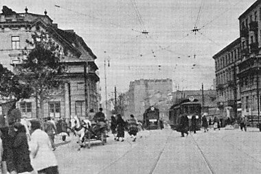
Wolska is the main artery of Warsaw's borough of Wola. Initially Wola district was but a western suburb of Warsaw and a road leading to it was dubbed "droga wolska" - Wola road. In 1725 parts of that road closest to the Warsaw Old Town, located along the Saxon Axis, were officially renamed to "Aleja Wolska" - Wola Avenue. In modern times it starts at a crossing of Chłodna and Towarowa Streets, and runs as a continuation of Solidarity Avenue through the neighbourhoods of Młynów, Czyste and Ulrychów, all the way to Połczyńska Street.
Source: Wikipedia
Meer informatie en contact
Wolska Street, Warsaw – Aan je reis toevoegen
Maak een gedetailleerde reisroute met slimme routing, tijdsinschattingen en alles wat je nodig hebt voor een perfecte reis.