Ho Bay

landingPages.LANDING_PAGE.DETAIL.LOCAL_NAMEHo Bugt
landingPages.LANDING_PAGE.DETAIL.LOCATIONNationalpark Vadehavet

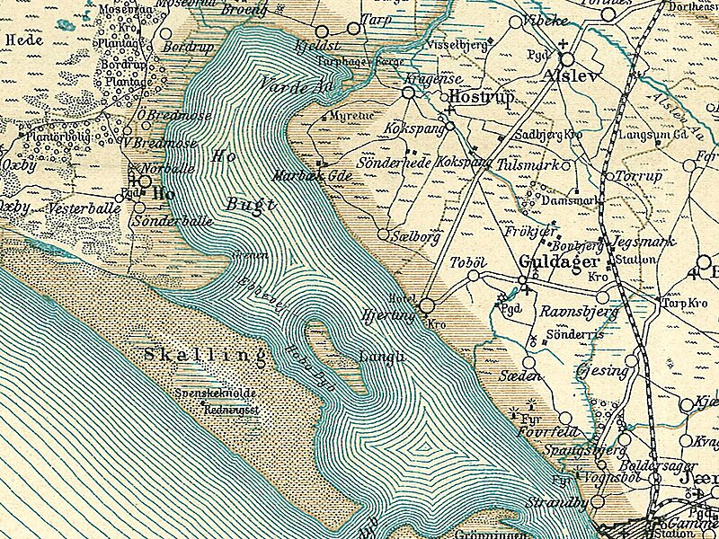
Ho Bay is a Danish bay with an approximate area of 50 square kilometres. It constitutes the northern end of the Wadden Sea, and lies between Skallingen in the southwest, Ho in the west, Oksbøl to the north and Hjerting to the east. At the northeastern end, Varde Å has its outlet through Tarp and Billum Enge, north of Marbæk Plantage.

In the southern end of the bay lies the island Langli surrounded by large sandy surfaces, but with a road to the north to the peninsula Nyeng, south of Ho.

landingPages.LANDING_PAGE.DETAIL.TAGS Bukt
landingPages.LANDING_PAGE.BUTTONS.DOWNLOAD landingPages.LANDING_PAGE.BUTTONS.DOWNLOAD landingPages.LANDING_PAGE.BUTTONS.SEE_MORE
Map of Ho Bugt in Ribe… @ Fotolitograferede i Generalstabens Topografiske Afdeling
 

landingPages.LANDING_PAGE.DETAIL.MORE_INFORMATION_AND_CONTACT

Wikipedia https://en.wikipedia.org/wiki/Ho_Bay

landingPages.LANDING_PAGE.DETAIL.COORDINATES 55°33'53.349" N 8°16'29.653" E

landingPages.LANDING_PAGE.MOBILE_PANEL.HEADER

landingPages.LANDING_PAGE.MOBILE_PANEL.SUB_HEADER
landingPages.LANDING_PAGE.MOBILE_PANEL.FOOTER
landingPages.MOBILE.BANNER.TITLE landingPages.MOBILE.BANNER.DESCRIPTION
landingPages.MOBILE.BANNER.USE landingPages.MOBILE.BANNER.NOT_NOW