


Άλπεις Κάμνικ-Σάβινια
The Kamnik-Savinja Alps are a compact limestone range in northern Slovenia, with a small northern edge in Austria. Grintovec is the highest peak at 2,558 m, and almost 30 summits rise above 2,000 m. The range is close to Ljubljana, yet it feels remote, with steep grey walls above green glacial valleys, old farms and simple mountain huts.
Most visitors come for walking. Easy valley paths lead to waterfalls and spring pools, while marked mountain trails climb to huts and high passes. You can also drive scenic roads past farm stays, see the herdsmen's huts on a high pasture, or ski in winter. The range suits nature lovers who want a quiet base for a few days, from easy strolls to demanding summit hikes.

Άλπεις Κάμνικ-Σάβινια – Σχεδιάζεις ταξίδι;
Φτιάξε το δρομολόγιό σου ημέρα με την ημέρα στην εφαρμογή Tripomatic.


Πότε να πας
June to September is the main season. The mountain huts open, the high trails are mostly clear of snow, and the valleys are green. July and August are the warmest months, but afternoon storms are common in the mountains, so start hikes early. Spring brings full waterfalls and snow on the peaks, and autumn colours the larch and beech forests. In winter the high trails are for experienced mountaineers only, while the valleys offer cross-country skiing and frozen waterfalls.
The biggest annual event is the Shepherds' Ball (Ovčarski bal) in Jezersko, held on a Sunday in August. It marks the return of the sheep from the mountain pastures, with folk music, wool crafts and food cooked over an open fire.
Κορυφαία αξιοθέατα





- Logar Valley (Logarska dolina): This glacial valley is the most famous part of the range. It has about 20 waterfalls, flower meadows and old farms below sheer walls, and it has been a landscape park since 1987.
- Rinka Waterfall falls about 105 m, with a main drop of 90 m, at the head of the Logar Valley. A short forest path leads to its foot, and in winter it freezes and draws ice climbers.
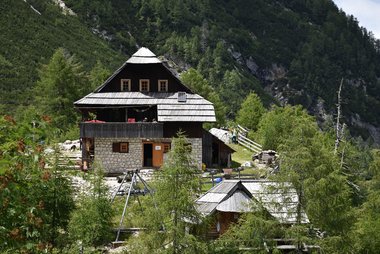
- Frischauf Lodge at Okrešelj stands in the Okrešelj cirque above the waterfall, ringed by high peaks. A hut has stood here since 1876, and the walk up from the valley takes about 1–1.5 hours.
- Robanov kot: This quiet side valley near Solčava has no through road and few visitors. A gentle path leads past farms into a narrow, wooded valley under steep cliffs.
- Matkov kot and the Solčava Panoramic Road: The 37 km road climbs high above the valleys, past farms, a hilltop church and viewpoints over the main ridge. A side road drops into Matkov kot, a wild valley north of the Logar Valley.
- Velika Planina is a high pasture with a village of oval herdsmen's huts. A cable car climbs to it from the Kamniška Bistrica valley.
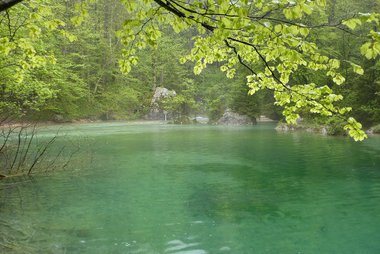
- Kamniška Bistrica Spring is a clear spring pool at the head of the Kamniška Bistrica valley, the main trailhead on the southern side. The narrow Predaselj gorge is a short walk away.
- Kamnik Saddle Lodge sits on a pass at 1,864 m between the Kamniška Bistrica valley and the Logar Valley. It is a popular day hike with wide views north and south.
- Grintovec is the highest peak of the range. Its summit trails are long and steep, with some exposed sections, and the view takes in much of Slovenia.
- Lake Planšar is a small lake in Jezersko, under the walls of the Ravenska Kočna valley. An easy path circles it, and Czech Lodge at Spodnje Ravni, built by Czech mountaineers in 1900, is a steep walk above.
Προτεινόμενες λίστες

Kamnik–Savinja Alps Must-Sees
The Kamnik–Savinja Alps in northern Slovenia feature dramatic limestone peaks, including Grintovec, the range's highest point at 2,558 meters. The region is defined by the glacial Logar Valley, home to the 90-meter Rinka Waterfall, and the high-mountain plateau of Velika Planina, known for its traditional wooden shepherd huts. Visitors can explore the Dovžan Gorge's Paleozoic fossils or access high-altitude terrain via the Krvavec and Velika Planina cable cars. Numerous mountain lodges provide base points for technical climbs and hiking trails.
20 μέρη


Historic Sites and Monuments
This collection showcases the architectural and wartime heritage of the Kamnik-Savinja Alps. It features well-preserved estates like Grad Strmol and Grad Turn, alongside the remnants of medieval fortifications and archaeological settlements like Gradišče nad Bašljem. The list also highlights significant World War II sites, including hidden partisan hospitals and memorials to fallen soldiers, reflecting the region's strategic and cultural history.
15 μέρηΤι να ζήσεις
These are the things people come back for in the Kamnik-Savinja Alps.
- Sleep in a mountain hut: Spend a night at a staffed hut, eat a simple hot meal, and catch sunrise over the peaks. Huts are open mainly from June to September; book ahead on summer weekends.
- Drive or cycle the Solčava Panoramic Road: Stop at the viewpoints and tourist farms on the way, and buy homemade cheese or bread.
- Cross a pass on foot: Walk from one valley to another over a high pass, such as the Kamnik Saddle, and return by a different route.
- Ice climbing and winter walks: In cold winters the waterfalls of the Logar Valley freeze, and the valley floors of the Logar Valley and Jezersko have groomed cross-country ski trails.
- Join the Shepherds' Ball: In August, watch the sheep come down to Jezersko and join the folk festival in the valley.
- Watch cheese-making on Velika Planina: In the grazing season, herdsmen on Velika Planina make and sell their own cheese, including the small decorated trnič.
Περιηγήσεις και δραστηριότητες
Άλπεις Κάμνικ-Σάβινια — Χάρτης

Ημερήσιες εκδρομές
The range sits between the Ljubljana Basin and the Savinja valley, so towns on both sides make easy day trips. Times are from the Kamniška Bistrica or Jezersko side unless noted.
- Kamnik: about 20 minutes by car from Kamniška Bistrica. A small medieval town with two castle hills, a monastery and a pleasant old street.
- Kranj: about 30 minutes by car from Jezersko. An old town on a rocky ridge above the Kokra river canyon.
- Ljubljana: about 45 minutes by car. Slovenia's capital has a compact old town, a castle and cafés along the river.
- Velenje: about 1 hour by car from the Logar Valley. A modern town with a castle museum and a lake for swimming and walks.
- Celje: about 1 hour 15 minutes by car from the Logar Valley. A historic town below a large medieval castle.
- Bled: about 50 minutes by car from Jezersko. The famous lake with its island church and cliff-top castle.
Μέρη για εξερεύνηση
The Kamnik-Savinja Alps are one of three mountain areas in northern Slovenia. To the west rise the higher Julian Alps, home to Triglav, Slovenia's highest peak. To the north, along the Austrian border, run the Karavanks and Pohorje, a long ridge with the wooded Pohorje hills further east.
Πώς να πας
The range has three main entry points: the Kamniška Bistrica valley in the south, Jezersko in the west and the Logar Valley in the north-east. Each is reached by a separate road, so plan your base around the side you want to explore.
- By air: Ljubljana Jože Pučnik Airport is the nearest airport, about 28 km from Kamniška Bistrica. There is no direct public transport into the valleys, so rent a car or take a taxi. Klagenfurt Airport in Austria is a practical option for Jezersko, via the Seeberg Saddle pass.
- By train: Trains run from Ljubljana to Kamnik in about 40 minutes. From Kamnik, continue by bus or taxi into the Kamniška Bistrica valley. Slovenian Railways
- By bus: Frequent buses link Ljubljana and Kamnik, and a few go on to Kamniška Bistrica. Buses run from Kranj to Jezersko. In summer, seasonal buses connect the Logar Valley with Celje and Velenje; check the dates each year. Logar Valley – getting there
- By car: Kamniška Bistrica is about 45 minutes from Ljubljana, and Jezersko about 1 hour via Kranj. The Logar Valley is about 1.5 hours from Ljubljana on winding roads through Kamnik and the Upper Savinja valley.
Μετακινήσεις
- Car: The valleys are not linked by roads across the range, so a car is the easiest way to move between them.
- Bus: Valley buses are infrequent. In summer, a hop-on, hop-off circular bus links Solčava, Luče, Kamnik, Preddvor and Jezersko on a loop around the range; it must be booked in advance.
- Logar Valley access: On busy summer days, car access into the valley may be limited, and visitors may need to park before the park entrance. Check the park website before you go.
- Cable car: The Velika Planina cable car leaves from the Kamniška Bistrica valley; tickets are sold at the lower station.
- On foot: Marked trails link the valleys over the passes, with mountain huts along the way. This is the classic way to cross the range.
- Cycling: Valley roads and the Solčava Panoramic Road are popular with road cyclists and e-bikers, but expect long, steep climbs.
Οδήγηση
- Is a car worth it?: Yes. Buses into the valleys are rare, and each valley has its own access road.
- Logar Valley fee: In the main season, cars pay an entry fee to drive into the Logar Valley landscape park; walkers and cyclists enter free. On busy days, private cars may be stopped at car parks before the valley.
- Parking: Trailhead car parks at Kamniška Bistrica, Jezersko and the Logar Valley fill early on summer weekends; arrive before 9 am.
- Mountain roads: Roads are narrow and winding, with steep sections on the Solčava Panoramic Road and the passes. Mountain roads can close or need winter tyres or chains in winter.
- Motorways: The fastest approach roads from Ljubljana use motorways, which need an e-vignette.
Φαγητό & ποτό
Food here is simple, filling farm cooking. Look for štruklji (rolled dumplings with cottage cheese), žganci (buckwheat mush), sausages, and lamb from the local Jezersko-Solčava sheep. Mountain huts serve hearty soups such as ričet (barley stew) and jota, which taste best after a long climb. On Velika Planina, try trnič, a small hard cheese pressed into a pear shape and decorated with patterns.
The best places to eat are the tourist farms (turistične kmetije) in the Logar Valley, around Solčava and in Jezersko. Many serve their own meat, dairy and bread, and some rent rooms. In summer, the mountain dairy farms sell fresh cheese and sour milk.
Ασφάλεια & υγεία
The valleys are very safe, and crime against visitors is rare. The real risks are in the mountains:
- Mountain trails: Many routes to the peaks are steep and exposed, with steel cables and pegs on rocky sections. Wear proper boots, carry water and a map, and turn back if a route is beyond your experience.
- Weather: Afternoon thunderstorms are common in summer. Start early and be off the ridges by early afternoon.
- Snow: Snow can stay in gullies and on north faces into early summer. Above the valleys, winter routes need ice axe, crampons and avalanche knowledge.
- Ticks: Ticks are common in forests and meadows, and they can carry tick-borne encephalitis. Check your skin after walks.
- Rescue: Call 112 for mountain rescue. Mobile signal can be weak in deep valleys and on north faces.
Ιστορία
People reached these mountains long before farmers did. Potočka zijalka, a cave high on Olševa above Solčava, holds traces of Ice Age hunters from tens of thousands of years ago. Excavations there from 1928 to 1935 found stone and bone tools, including one of the oldest known sewing needles.
For centuries, the main ridge marked the border of three historical lands: Carniola, Styria and Carinthia. They met on the summit of Carinthian Rinka, above the Okrešelj cirque. The western part of the range was named the Kamnik Alps in 1778, after the town of Kamnik. The eastern part was named the Savinja Alps in 1875 by the mountaineer Johannes Frischauf.
Frischauf helped open the range to hikers. The first hut at Okrešelj, now Frischauf Lodge at Okrešelj, opened in 1876, and Czech climbers built Czech Lodge at Spodnje Ravni in 1900. During the Second World War, partisans hid hospitals in the forests, and much of the herdsmen's village on Velika Planina was burned. The herders later rebuilt it in the traditional style.
Στοιχεία για τη χώρα
Quick practical facts for Slovenia at a glance:
- Νόμισμα
- Ευρώ EUR · Πληρωμές με κάρτα · Ευρέως αποδεκτές
- Τηλέφωνα έκτακτης ανάγκης
- 112
- Ηλεκτρικό ρεύμα
- 230 V · 50 HzΤύπος C / Τύπος F
- Γλώσσες
- Σλοβενικά
- Νερό βρύσης
- Πόσιμο
- Πλευρά οδήγησης
- Δεξιά
- Κωδικός κλήσης
- +386


Άλπεις Κάμνικ-Σάβινια – Σχεδίασε τις ημέρες σου
Μετάτρεψε τα μέρη από αυτόν τον οδηγό σε ένα πραγματικό δρομολόγιο, με έξυπνη δρομολόγηση, εκτιμήσεις χρόνου και όλα όσα χρειάζεσαι για ένα τέλειο ταξίδι.


Σχετικοί προορισμοί




Data: © OpenStreetMap contributors, Wikidata, Wikipedia, Tripomatic, Official websites. Tours by GetYourGuide. We earn commission from bookings. Travel guide generated with AI.
Σχεδίασε το ταξίδι σου με το Tripomatic
- Σχεδιασμός με AIΆφησε το AI να δημιουργήσει το δρομολόγιό σου, να απαντήσει σε ταξιδιωτικές ερωτήσεις και να αρχειοθετήσει τα έγγραφα των κρατήσεών σου στο ταξίδι σου.
- Ταξιδιωτικές ειδοποιήσειςΕπίσημες ταξιδιωτικές οδηγίες, έντονα καιρικά φαινόμενα, απεργίες και φυσικοί κίνδυνοι για τα μέρη σε κάθε ημέρα του ταξιδιού σου.
- Επίσημες αργίες & ΕκδηλώσειςΔες αργίες, φεστιβάλ και ημέρες μη λειτουργίας κατά τις ημέρες του ταξιδιού σου και πώς επηρεάζουν τα σχέδιά σου.
- Εκτίμηση κόστουςΑνάλυση του κόστους του ταξιδιού με AI, ώστε να γνωρίζεις τον προϋπολογισμό σου πριν ξεκινήσεις.
- Περιηγήσεις & ΕισιτήριαΚλείσε περιηγήσεις, εισιτήρια χωρίς αναμονή στην ουρά και δραστηριότητες απευθείας στο πλάνο σου.