


Azorit
The Azores are nine volcanic islands scattered across the mid-Atlantic, about 1,500 km from mainland Portugal. Green pastures run down to black lava cliffs, and each island has its own crater lakes, hot springs, or whale-watching grounds. Towns are small, roads wind along the coast, and much of the landscape is protected nature reserve or working farmland.
This suits hikers, nature lovers, and anyone who wants dramatic scenery without crowds — it is not known for beach resorts or nightlife. A week is enough time to explore one or two islands properly. Seeing several means short inter-island flights or ferries.

Azorit – Suunnitteletko matkaa?
Rakenna päiväkohtainen matkasuunnitelmasi Tripomatic-sovelluksessa.


Milloin matkustaa
Summer, from June to September, is the warmest and driest season, with the best odds of sun for hiking and boat trips. Spring and autumn are mild but rainy, and winter brings wind and rough seas.
The Sanjoaninas festival fills Terceira Island for a week in late June, with concerts, traditional bull-running through the streets, and an island-wide holiday mood. It is worth visiting that week if you can.
Paras aika matkustaa: heinäkuu, elokuu
Päänähtävyydet



On São Miguel, the largest island, Lagoa do Fogo fills a volcanic crater with intensely blue water, ringed by cliffs and reached by a short hike. Nearby, the twin crater lakes of Sete Cidades sit side by side, one tinted green and the other blue.
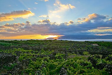
On Pico, Montanha do Pico is Portugal's highest point at 2,351 meters, a dormant volcano that dominates every view on the island. Its lower slopes hold Landscape of the Pico Island Vineyard Culture, a UNESCO World Heritage landscape of black stone-walled vineyards built to shelter grapevines from Atlantic winds.
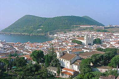
Terceira's former capital survives almost intact at Centro Histórico de Angra do Heroísmo, a UNESCO-listed old town of pastel facades and baroque churches founded in 1478. A short drive away, Algar do Carvão drops visitors down a 338-step staircase into a huge volcanic chimney with its own underground pond.
On Faial, Capelinhos Volcano is a stark, ash-grey landscape from an eruption that lasted 13 months in 1957 and 1958, still visible around a half-buried lighthouse. On Graciosa, Furna do Enxofre is a cave holding an underground lake, reached through a natural chimney in the volcanic dome above it.
On Flores, Poço da Ribeira do Ferreiro is a pond fed by waterfalls that drop 300 meters down a cliff face, reached by a hiking trail. On Corvo, Caldeirão is a collapsed volcanic caldera holding wetlands and two lagoons at the island's summit, reached by a hiking trail from the village. On Santa Maria, Baía de São Lourenço is a shell-shaped bay ringed by terraced vineyards on the clifftops, with a beach and natural swimming pools below.
Suositellut listat


Hidden Gems of the Azores
The Azores archipelago features diverse volcanic landscapes and historical landmarks. This selection includes the 18th-century Terra Nostra Garden, known for its geothermal pool and botanical collection, and the neo-Gothic Chapel of Nossa Senhora das Vitórias on the shores of Furnas Lake. Natural highlights include the Sete Cidades caldera at Vista do Rei, the northern coastal views from Miradouro do Pico Vermelho, and Mount Pico, Portugal's highest point at 2,351 meters. These sites represent the region's unique blend of tectonic activity and curated heritage.
5 paikkaa
Best Beaches and Coasts
The Azores archipelago offers a diverse range of coastal environments, from the volcanic black sands of Praia das Milícias and Praia do Almoxarife to the natural basalt swimming pools of Calheta dos Biscoitos and Porto Martins. On São Miguel, Praia do Fogo features waters warmed by hydrothermal vents, while Santa Maria’s Praia de São Lourenço is framed by terraced vineyards. These locations provide varying conditions, including world-class surf breaks at Areal de Santa Barbara and sheltered sandy bays like Prainha.
12 paikkaa


Iconic Azores Lighthouses
The Azores archipelago features a network of historic lighthouses strategically positioned along volcanic cliffs and rugged headlands. These maritime landmarks range from the ruins of Farol da Ribeirinha, damaged by a 1998 earthquake, to the partially buried Farol dos Capelinhos, a relic of the 1957 volcanic eruption. Each beacon, such as the 19th-century Farol do Arnel, highlights the islands' architectural heritage and provides critical navigation across the central Atlantic.
10 paikkaa
Museums & Cultural Centers
This collection explores the industrial and cultural heritage of the Azores across several islands. It features Europe’s oldest tea plantations on São Miguel, UNESCO-recognized viticulture on Pico, and the volcanic history of Faial. Visitors can examine 19th-century whaling equipment, traditional linen weaving, and military history housed in 16th-century forts. From the underground Capelinhos Volcano Interpretation Centre to the natural history collections of the Carlos Machado Museum, these sites document the archipelago’s unique geological and social evolution.
15 paikkaa
Parks and Gardens
The Azores offer a unique blend of volcanic geology and lush botanical heritage. This collection features the 18th-century Terra Nostra Garden with its iron-rich thermal waters and the romantic 19th-century Jardim António Borges, famous for its lava-rock grottos. Explore the terraced slopes of Angra do Heroísmo at Jardim Duque da Terceira or the waterfalls and restored watermills of Ribeira dos Caldeirões. From the high-altitude crater of Lagoa do Fogo to the exotic species in Jardim José do Canto, these spaces showcase endemic Macaronesian flora alongside global plant collections.
8 paikkaa
Best Regional Cuisine
This collection highlights the culinary traditions of the Azorean archipelago, centering on the volcanic landscape of São Miguel, the vineyards of Pico, and the pastures of Terceira. Key highlights include the Cozido das Furnas, a stew slow-cooked in the heat of active fumaroles, and the Bife à Associação, showcasing the region’s grass-fed beef. The selection also features seaside eateries specializing in fresh Atlantic catches and historic taverns serving local cheeses and wines produced in unique volcanic soils.
14 paikkaa
Best Viewpoints in the Azores
The Azores archipelago, a volcanic chain in the North Atlantic, features a diverse landscape of calderas, thermal fields, and sheer coastal cliffs. This collection highlights key vantage points across the islands, from the iconic twin lakes of Sete Cidades and the high-altitude crater of Lagoa do Fogo to the unique 'patchwork' pastures of Terceira's Serra do Cume. These sites provide direct views of basaltic formations, endemic Macaronesian flora, and the dramatic geological results of centuries of seismic activity.
20 paikkaa

Traditional Windmills
The Azores archipelago features a diverse collection of traditional windmills, reflecting the region's agricultural history and Flemish architectural influences. These structures vary by island: Pico is known for its iconic red-capped stone towers set against volcanic vineyards, while Graciosa features windmills with distinctive red conical roofs. Historically used for grinding grain, these restored landmarks illustrate the evolution of rural engineering across São Miguel, Santa Maria, and Pico, often positioned on coastal ridges to capture Atlantic winds.
10 paikkaaMitä kokea
- Soak in Poça da Dona Beija, four open-air pools in Furnas heated to around 39°C by volcanic springs, open for day and evening bathing.
- Swim where a hot spring meets the ocean at Ponta da Ferraria, a natural pool on São Miguel's coast warmed by geothermal heat even as Atlantic waves wash in.
- Tour and taste tea at Chá Gorreana Tea Factory, Europe's oldest working tea plantation, still run on nineteenth-century machinery.
- Join a boat trip to watch whales and dolphins. The deep waters around the islands attract more than 20 species, with sperm whales present year-round and easiest to spot in summer.
Kierrokset ja aktiviteetit
Azorit — Kartta

Päiväretket
Most travelers base themselves on one island and see its highlights, but a few short crossings make easy day trips.
- Pico Island from Faial Island — the car ferry between Horta and Madalena takes about 30 minutes and runs several times a day. An easy way to see Pico's vineyards and volcano in a single day.
- Faial Island from Pico Island — the same ferry in reverse, for a day around Horta's marina and Faial's hiking trails.
- São Jorge Island from Pico — about 50 minutes by ferry, to see São Jorge's fajãs, flat lava ledges below tall cliffs. The ferry from Faial takes longer, around 1.5–2 hours.
- Corvo Island from Flores Island — a 40–55 minute boat crossing, weather permitting. Corvo's single village sits on the coast beneath the island's volcanic crater; most visitors see it as a day trip since the island has almost no accommodation.
Missä vierailla
The Azores split into three groups. In the east, São Miguel Island is the largest and most visited island, with Santa Maria Island a short flight south.
In the center, five islands sit close together: Terceira Island, Graciosa Island, São Jorge Island, Pico Island, and Faial Island. Ferries connect them in summer, making island-hopping easy.
Far to the west, Flores Island and Corvo Island are the most remote and least visited islands, reachable only by small plane or boat.
Saapuminen
- By air: João Paulo II Airport (PDL) in Ponta Delgada, on São Miguel, is the main international gateway, with direct flights from Lisbon, Porto, and seasonal routes from North America. The airport sits about 3 km from the city center; a taxi takes 10–15 minutes.
- Each of the other eight islands has its own small airport with scheduled flights from São Miguel, run by Azores Airlines — useful for reaching Terceira, Faial, or Pico directly without connecting through Ponta Delgada.
- There is no scheduled passenger ferry from mainland Portugal; flying is the only way in.
Liikkuminen paikan päällä
- Public transit: each island has a local bus network, but service is infrequent and aimed mainly at residents. A rental car is the practical way to see the sights on any island.
- Inter-island travel: Azores Airlines flies between the islands. Ferries connect the five central islands — Terceira, Graciosa, São Jorge, Pico, and Faial — mainly in summer, and a separate boat links Flores and Corvo, weather permitting.
- Taxi: regular taxis operate on every island, but ride-hailing apps have little to no presence. Arrange a taxi by phone or through your accommodation.
- On foot: town centers are small and walkable, but distances between sights mean you need a car or an organized tour.
Autoilu
- Is a car worth it? Yes, for exploring beyond each island's main town — public transport is limited and sights are spread out.
- Parking is mostly free, on-street or in small car parks near town centers.
- No restrictions: there are no congestion charges or low-emission zones on any island.
Ruoka ja juoma
Azorean food comes from what the volcanic soil and surrounding ocean provide. The signature dish is cozido das Furnas, a stew of meats and vegetables slow-cooked for hours in pots buried in geothermally heated volcanic ground — ask locally about tours that include a cozido lunch. Fresh tuna, limpets, and barnacles appear on most menus, and Pico's volcanic-soil vineyards produce distinctive mineral white wines worth trying.
Tipping and dining customs follow mainland Portugal: rounding up or leaving 5–10% is appreciated but not expected.
Turvallisuus ja terveys
The Azores are very safe for travelers; petty crime and scams are rare even in tourist areas. The main risks are natural rather than criminal: crater rim trails can be slippery and exposed, coastal rocks are often wet and dangerous to swim near, and sea conditions can turn rough with little warning. Roads are narrow and winding in the interior, so drive carefully and watch for livestock crossing.
Historia
The islands were uninhabited until Portuguese sailors settled them in the 15th century, during the early Age of Discovery. Centro Histórico de Angra do Heroísmo grew into one of the Atlantic's most important ports, a stopover for ships sailing between Europe and the Americas. It briefly served as the seat of the Portuguese crown during the Liberal Wars in the 1830s.
Whaling shaped island life for centuries; the Whalers Museum traces this history through the tools and boats once used to hunt sperm whales by hand. The 1957–58 eruption at Capelinhos Volcano buried farmland and homes in ash. It set off a wave of emigration to the United States that still shapes Azorean communities in New England today.
Tietoa maasta
Quick practical facts for Portugal at a glance:
- Valuutta
- euro EUR € · Korttimaksut · Laajasti hyväksytty
- Hätänumerot
- 112
- Sähkö
- 230 V · 50 HzTyyppi C / Tyyppi F
- Kielet
- portugali
- Hanavesi
- Juomakelpoista
- Ajosuunta
- Oikea
- Suuntanumero
- +351


Azorit – Suunnittele päiväsi
Muunna tämän oppaan paikat todelliseksi matkasuunnitelmaksi älykkäillä reiteillä, aika-arvioilla ja kaikella, mitä tarvitset onnistuneeseen matkaan.


Liittyvät määränpäät


Data: © OpenStreetMap contributors, Wikidata, Wikipedia, Tripomatic, Official websites, geoBoundaries (CC BY 4.0). Tours by GetYourGuide. We earn commission from bookings. Travel guide generated with AI.
Suunnittele matkasi Tripomaticilla
- Tekoälypohjainen suunnitteluAnna tekoälyn rakentaa matkasuunnitelmasi, vastata matkakysymyksiin ja arkistoida varausasiakirjasi matkaasi.
- MatkustustiedotteetViralliset tiedotteet, vaaralliset säät, lakot ja luonnonkatastrofit matkasi jokaisen päivän paikkoihin.
- Juhlapyhät ja tapahtumatNäe matkasi päiville osuvat lomat, festivaalit ja sulkuajat sekä niiden vaikutus suunnitelmiisi.
- KustannusarvioTekoälypohjaiset matkakustannuserittelyt auttavat sinua hahmottamaan budjetin ennen lähtöä.
- Kierrokset ja liputVaraa kierroksia, jonon ohi -lippuja ja aktiviteetteja suoraan suunnitelmaasi.