


Frederikshavn
Frederikshavn is a working port town on the east coast of North Jutland, facing the Kattegat. Most visitors know it as a ferry hub: ships leave here for Gothenburg in Sweden and for the island of Læsø. The station sits between the town centre and the harbour, so arriving by train and leaving by boat is easy.
The town is worth more than a quick change of transport. The forest of Bangsbo on the southern edge holds a manor-house museum, a deer park and a German coastal fort from the Second World War. In summer, a palm-lined town beach and a tall viewing tower add a relaxed side. Frederikshavn also works as a cheaper, quieter base for Skagen, about 40 minutes north by train.

Frederikshavn – Suunnitteletko matkaa?
Rakenna päiväkohtainen matkasuunnitelmasi Tripomatic-sovelluksessa.


Milloin matkustaa
Summer is the best time to visit. July and August are the mildest months, the days are very long, and the beach and museums have their longest hours. Spring and autumn are cool and windy, and winters are dark and wet, with some snow.
The biggest local event is the Tordenskiold festival, held over a weekend in late summer. The area around Krudttårnet becomes the port of Fladstrand in the early 1700s, with market stalls, music and costumed re-enactors, in memory of the naval hero Peter Tordenskiold.
Paras aika matkustaa: heinäkuu
Päänähtävyydet
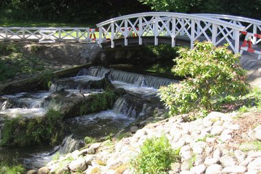


Bangsbo Museum fills an old moated manor in Bangsbo forest, on the southern edge of town. Its exhibitions include a 12th-century ship found in a local stream, the Danish resistance movement, a carriage collection and a large collection of jewellery made from human hair. A small botanical garden and Bangsbo Dyrehave, a fenced forest park with about 40 free-roaming fallow, red and sika deer, are next door.
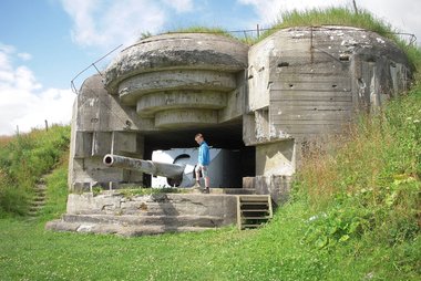
On a hill just south of the museum, Kystmuseet Bangsbo Fort - Bunker Museum is a coastal battery the German navy built in 1940 to guard the harbour. About 70 concrete bunkers and gun positions survive, and on a clear day the view reaches Sæby, Skagen and Læsø. The museum is closed in winter, so check its opening times before you go.
Down by the harbour, Krudttårnet is a round gunpowder tower from the 1680s and the town's symbol. In the 1970s the whole tower was moved about 270 m to make room for the shipyard's expansion.
North of the centre, Fiskerklyngen is the oldest part of town, a former fishing village. Its low, colourful cottages date mostly from the 18th and 19th centuries.
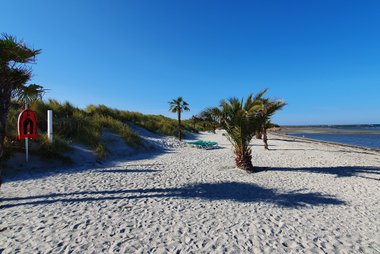
Palmestranden is the town beach, about 2 km north of the centre. Through the summer, dozens of palm trees stand in the sand. It has a Blue Flag, beach volleyball courts and lifeguards in high season.
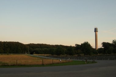
West of town, Cloostårnet is a 60 m viewing tower on a hilltop, with its top 160 m above sea level. Take the lift or climb 315 steps for wide views over the region and, on clear days, to Skagen and the Kattegat islands.
Kierrokset ja aktiviteetit
Frederikshavn — Kartta

Saapuminen
- By train: Regional trains run from Aalborg in about 1 hour 15 minutes to 1 hour 30 minutes, with connections from there to the rest of Denmark. Local trains continue to Skagen in about 40 minutes. The station is between the town centre and the harbour, next to the bus station.
- By air: Aalborg Airport is the nearest airport with scheduled flights, about 65 km away. Take a bus or taxi to Aalborg station, then the train to Frederikshavn.
- By ferry: Stena Line sails to Gothenburg in Sweden several times a day, and the crossing takes about 3.5 hours. The Læsø ferry reaches Læsø in about 90 minutes.
- By car: The E45 motorway runs north from Aalborg and ends in Frederikshavn.
- Tickets: For buses and local trains in North Jutland, buy tickets in the Rejsebillet app or use Rejsekort. See NT (Nordjyllands Trafikselskab) for journey planning.
Tietoa maasta
Quick practical facts for Denmark at a glance:
- Valuutta
- Tanskan kruunu DKK kr · Korttimaksut · Laajasti hyväksytty
- Hätänumerot
- 112
- Sähkö
- 230 V · 50 HzTyyppi C / Tyyppi E / Tyyppi F / Tyyppi K
- Kielet
- tanska
- Hanavesi
- Juomakelpoista
- Ajosuunta
- Oikea
- Suuntanumero
- +45


Frederikshavn – Lisää matkaan
Luo yksityiskohtainen matkasuunnitelma älykkäillä reiteillä, aika-arvioilla ja kaikella, mitä tarvitset täydelliseen matkaan.


Liittyvät määränpäät


Data: © OpenStreetMap contributors, Wikidata, Wikipedia, Tripomatic, Official websites. Tours by GetYourGuide. We earn commission from bookings. Travel guide generated with AI.
Suunnittele matkasi Tripomaticilla
- Tekoälypohjainen suunnitteluAnna tekoälyn rakentaa matkasuunnitelmasi, vastata matkakysymyksiin ja arkistoida varausasiakirjasi matkaasi.
- MatkustustiedotteetViralliset tiedotteet, vaaralliset säät, lakot ja luonnonkatastrofit matkasi jokaisen päivän paikkoihin.
- Juhlapyhät ja tapahtumatNäe matkasi päiville osuvat lomat, festivaalit ja sulkuajat sekä niiden vaikutus suunnitelmiisi.
- KustannusarvioTekoälypohjaiset matkakustannuserittelyt auttavat sinua hahmottamaan budjetin ennen lähtöä.
- Kierrokset ja liputVaraa kierroksia, jonon ohi -lippuja ja aktiviteetteja suoraan suunnitelmaasi.