


אפנצל
Appenzell is a small village in northeastern Switzerland, below the Alpstein mountains. The main street has brightly painted houses with flower boxes and carved signs. Farms and meadows surround it.
The village is the capital of the half-canton of Appenzell Innerrhoden. It is known for traditional customs, cheese and hiking. Most visitors come for a day or a few nights.

אפנצל – מתכנן טיול?
בנה את המסלול היומי שלך באפליקציית Tripomatic.


מתי לבקר
June to September is the best time for hiking and the high cable cars. Spring brings flowers and fresh green meadows. Autumn is clear and has the cattle processions when herds come down from the mountains. Winter is snowy and cold, and some mountain paths close. On the last Sunday of April, citizens vote in the open air at the Landsgemeinde.
אטרקציות מובילות

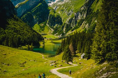



- Säntis is the highest peak in the Alpstein. A cable car climbs from Schwägalp, and the summit has views of six countries on a clear day.
- Ebenalp is reached by cable car from Wasserauen. Trails lead to the cave church and a cliff-side inn.
- Seealpsee is a mountain lake reached by a walk of about 1 hour from Wasserauen.
- Pfarrkirche St. Mauritius is the village church, with a painted interior.
- Brauerei Locher is a local brewery with a visitor centre.
- Museum Appenzell tells the story of local customs and crafts.
- Kunstmuseum Appenzell shows art in a modern building.
- Klosterkirche is a small church in the village.
רשימות מומלצות

חוויות מומלצות
- Walk the painted main street and look at the carved signs.
- Ride the cable car to Ebenalp and walk to the cave church.
- Walk to Seealpsee and swim or rest at the lake.
- Ride to the Säntis summit for views.
- Visit the brewery and taste local beer.
- Hike on marked trails in the Alpstein hills.
סיורים ופעילויות
אפנצל — מפה

טיולי יום
- Wasserauen is about 15 minutes away by train. It is the start of the paths to Ebenalp and Seealpsee.
- Schwägalp, the base of the Säntis cable car, is reached by bus and takes about 1 hour.
- St. Gallen is about 50 minutes away by train.
- Lake Constance is about 1 hour away.
איך מגיעים
- By air: Zurich Airport is the nearest main airport. The trip takes about 2 hours by train.
- By train: Appenzell is on a narrow-gauge line from St. Gallen. Check times on SBB.
- Trains also run on to Wasserauen.
איך מתניידים
- The village is small and easy to walk.
- Local trains and buses reach the mountain stations.
- The cable cars to Ebenalp and Säntis run all year, with breaks for maintenance.
- Hiking paths link the village to nearby farms and hills.
נהיגה
- A car is not needed in the village. Public transport reaches the mountain stations.
- Parking in the village is limited at busy times.
- Mountain roads can be steep and narrow.
אוכל ושתייה
Try Appenzeller cheese, a strong cheese ripened in herb brine. Appenzeller Biberli are filled gingerbread. Local sausages and dried meats are common. The herbal liqueur Alpenbitter comes from the area.
The region keeps old customs, such as yodelling, folk music and the Landsgemeinde. Local people speak a distinctive German dialect.
בטיחות ובריאות
- Appenzell is very safe.
- Mountain weather can change fast. Check the forecast before any hike.
- Wear good boots on trails. Paths can be wet and steep.
- Tap water is safe to drink.
היסטוריה
Appenzell grew around an abbey of St. Gall. The area joined the Swiss Confederation in 1513. The region later split into two halves, Innerrhoden and Ausserrhoden, over religion in 1597.
Innerrhoden stayed Catholic, and the village kept its customs. Today it is a small canton with a strong local identity.
עובדות על המדינה
Quick practical facts for Switzerland at a glance:
- מטבע
- פרנק שוויצרי CHF CHF · תשלום בכרטיסי אשראי · מקובל באופן נרחב
- מספרי חירום
- 112
- חשמל
- 230 וולט · 50 הרץסוג C / סוג J
- שפות
- גרמנית, צרפתית, איטלקית, רומאנש
- מי ברז
- בטוח לשתייה
- צד הנהיגה
- ימין
- קידומת חיוג בינלאומית
- +41


אפנצל – תכנן את הימים שלך
הפוך את המקומות מהמדריך הזה למסלול אמיתי, עם ניתוב חכם, הערכות זמן וכל מה שדרוש לטיול מושלם.


יעדים קשורים
Data: © OpenStreetMap contributors, Wikidata, Wikipedia, Tripomatic, Official websites, geoBoundaries (CC BY 4.0). Tours by GetYourGuide. We earn commission from bookings. Travel guide generated with AI.
תכנן את הטיול שלך עם Tripomatic
- תכנון מבוסס AIתן ל-AI לבנות את המסלול שלך, לענות על שאלות לטיול ולתייק את מסמכי ההזמנה שלך בתוך הטיול.
- התרעות נסיעהאזהרות רשמיות, מזג אוויר קיצוני, שביתות וסכנות טבע עבור המקומות בכל יום של הטיול שלך.
- חגים ציבוריים ואירועיםצפה בחגים, פסטיבלים וסגירות בימי הטיול שלך, ומה משמעותם עבור התוכניות שלך.
- הערכת עלויותפירוט עלויות טיול מבוסס AI כדי שתדע איזה תקציב לתכנן מראש.
- סיורים וכרטיסיםהזמן סיורים, כרטיסים לעקיפת התור ופעילויות ישירות מתוך התוכנית שלך.