


ייראנגרפיורד
Geirangerfjord is a narrow fjord in western Norway. It is about 15 km long, with steep mountain walls and many waterfalls that fall straight into the water. UNESCO lists it with Nærøyfjord as the West Norwegian Fjords, a World Heritage Site since 2005. The small village of Geiranger sits at the head of the fjord.
It suits a stay of one to three nights built around boat trips, short hikes and mountain drives. Tourism is the main business in the village. The summer season is busy, and many cruise ships call at Geiranger. Outside the season the village is very quiet and some roads and services close.

ייראנגרפיורד – מתכנן טיול?
בנה את המסלול היומי שלך באפליקציית Tripomatic.


מתי לבקר
The main season runs from about May to early September. June to August has the longest days and the best chance of open mountain roads and running boat services. Rain is common in every month, and snow can stay on the high ground well into summer.
On days when cruise ships are in port the village and viewpoints are crowded. Ship schedules are published by the port.
Mountain roads such as the road to Dalsnibba and Trollstigen close in winter, and dates change with the snow. Check road status before you plan a drive.
אטרקציות מובילות

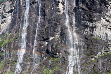


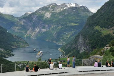
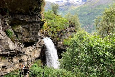
- Geirangerfjord og Nærøyfjord is the heart of the visit. The fjord is about 15 km long and very narrow, so the cliffs feel close from a boat or from the shore. It is a World Heritage Site that protects the steep landscape, the waterfalls and the old mountain farms.
- The Seven Sisters waterfall is the best known of the waterfalls, with seven separate streams. The Suitor (Friaren) falls face it across the fjord, and Bridal Veil (Brudesløret) is another famous one. All three are easiest to see from a fjord boat.
- Dalsnibba is a mountain summit at about 1,500 m. A private toll road with 11 hairpin bends leads to the top, where a skywalk viewing platform gives wide views. Snow can lie there even in midsummer.
- Flydalsjuvet is a gorge on County Road 63 with a viewpoint beside the road. It is a classic place to photograph the fjord from above.
- Ørnesvingen, on the Eagle Road (Ørnevegen), is a viewpoint on the hairpin road that climbs from Geiranger to about 620 m. It gives a wide view back over the fjord.
רשימות מומלצות


חוויות מומלצות
- Take a fjord cruise or sightseeing boat from the harbour to see the Seven Sisters, the Suitor and Bridal Veil from the water.
- Join a guided sea kayak tour on the fjord. Guided tours of different lengths run from Geiranger.
- Walk to the abandoned mountain farm of Skageflå. It lies about 250 m above the fjord. Allow 2 to 4 hours on foot from the village. A boat can take you part of the way.
- Visit the Norwegian Fjord Centre in Geiranger, the visitor and education centre for the World Heritage fjords. It is a good choice on a rainy day.
סיורים ופעילויות
ייראנגרפיורד — מפה

טיולי יום
Two trips are worth considering. The second takes a full day.
- Hellesylt: about 65 minutes by ferry along the fjord, when the ferry is operating. Check the operator before you plan this trip.
- Trollstigen and Åndalsnes: Trollstigen is a famous mountain road with 11 hairpin bends and a steep drop. It links Åndalsnes with the Geiranger area. The route uses the short Eidsdal–Linge ferry. The road is closed in winter.
היכן לטייל
איך מגיעים
- By air: Ålesund Airport Vigra (AES) is the main gateway, with flights from Oslo and other cities. Molde Airport Årø (MOL) is another option. Ørsta-Volda Airport Hovden is about 1 hour 50 minutes from Geiranger.
- By bus and ferry: when the ferry is operating, a bus runs from Ålesund to Hellesylt and the fjord ferry continues to Geiranger. Allow roughly half a day.
- By ferry: the Geiranger–Hellesylt ferry is a seasonal service (normally April to October, about 65 minutes, carries cars). It does not run every year or season, and the operator can suspend it, so check the Fjord1 page before building a plan around it: Fjord1 Geiranger–Hellesylt.
- By car: County Road 63 passes through the village. It links Geiranger with Åndalsnes over Trollstigen, using the Eidsdal–Linge ferry (about 10 minutes). Parts of the road close in winter.
- Road status: traffic information from the Norwegian Public Roads Administration.
איך מתניידים
- On foot: the village is small and you can walk around it. Most viewpoints and trails start outside the village and are steep.
- Taxi and bus tours: local operators run taxi and bus trips to Dalsnibba, so you do not need a car for the summit.
- E-bikes: rental is available in season.
- Boats: sightseeing boats, water taxis and kayak tours leave from the harbour.
נהיגה
- Is a car worth it? It helps if you want to visit Dalsnibba, the Eagle Road and Trollstigen on your own schedule. For the village and the fjord you do not need one.
- Mountain roads: roads are steep, with many hairpin bends. County Road 63 sections to Geiranger and over Trollstigen close in winter and spring, usually from early November to late May.
- Trollstigen: vehicles longer than 12.4 m are not allowed.
- Dalsnibba: the last 5 km is a private toll road. Buy the ticket before you drive.
אוכל ושתייה
Geiranger is small. Most cafés and restaurants are in the village by the harbour, and the choice is limited.
Places can fill up on cruise-ship days. Book ahead for dinner in the high season.
בטיחות ובריאות
Geiranger is very safe for visitors. The main risks come from the mountains and the weather.
- Mountain trails are steep and can be wet. Some viewpoints have sharp drops, so keep to marked paths and wear good shoes.
- Weather changes fast, and snow can remain high up in summer.
- The mountain Åkerneset above the fjord is monitored for rockslides, and warning sirens are installed. Follow local signs and instructions.
- Tap water is safe to drink.
היסטוריה
For centuries, farmers lived on narrow ledges high above the fjord. The farm at Skageflå was inhabited from the Middle Ages and was abandoned in 1916. It is now a tourist attraction. Another abandoned farm, Knivsflå, can be reached by boat.
Tourism later became the main business of Geiranger. In 2005, UNESCO inscribed the fjord, together with Nærøyfjord, as the West Norwegian Fjords (Geirangerfjord og Nærøyfjord on the map).
עובדות על המדינה
Quick practical facts for Norway at a glance:
- מטבע
- כתר נורווגי NOK kr · תשלום בכרטיסי אשראי · מקובל באופן נרחב
- חשמל
- 230 וולט · 50 הרץסוג C / סוג F
- שפות
- נורווגית ספרותית, נורווגית חדשה
- מי ברז
- בטוח לשתייה
- צד הנהיגה
- ימין
- קידומת חיוג בינלאומית
- +47


ייראנגרפיורד – תכנן את הימים שלך
הפוך את המקומות מהמדריך הזה למסלול אמיתי, עם ניתוב חכם, הערכות זמן וכל מה שדרוש לטיול מושלם.


יעדים קשורים


Data: © OpenStreetMap contributors, Wikidata, Wikipedia, Tripomatic, Official websites. Tours by GetYourGuide. We earn commission from bookings. Travel guide generated with AI.
תכנן את הטיול שלך עם Tripomatic
- תכנון מבוסס AIתן ל-AI לבנות את המסלול שלך, לענות על שאלות לטיול ולתייק את מסמכי ההזמנה שלך בתוך הטיול.
- התרעות נסיעהאזהרות רשמיות, מזג אוויר קיצוני, שביתות וסכנות טבע עבור המקומות בכל יום של הטיול שלך.
- חגים ציבוריים ואירועיםצפה בחגים, פסטיבלים וסגירות בימי הטיול שלך, ומה משמעותם עבור התוכניות שלך.
- הערכת עלויותפירוט עלויות טיול מבוסס AI כדי שתדע איזה תקציב לתכנן מראש.
- סיורים וכרטיסיםהזמן סיורים, כרטיסים לעקיפת התור ופעילויות ישירות מתוך התוכנית שלך.