


Quang Tri
Quảng Trị is a small coastal province in central Vietnam that was split by the Demilitarised Zone (DMZ) from 1954 to 1975. The Bến Hải River along the 17th parallel marked the border between North and South Vietnam. Today the war sites are the main reason to visit: the Vịnh Mốc tunnels, the Khe Sanh Combat Base, the Hiền Lương Bridge and the Citadel.
Most visitors come on a day trip from Huế or Đồng Hới. Allow one full day for the main DMZ sites, or two days at a slower pace.

Quang Tri – A planear uma viagem?
Cria o teu itinerário dia a dia na app Tripomatic.


Quando visitar
February to May is the best time. The weather is dry and warm. June to August is hot with strong dry wind from Laos. September to December is wet, with typhoons and floods. Winter can be grey and cool.
Principais atrações
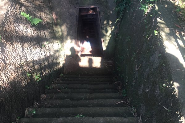
- Vịnh Mốc Tunnels Museum is a network of tunnels where a village lived underground during heavy bombing. Visitors walk through parts of it.
- Quảng Trị Citadel is the ruin of a citadel fought over in 1972. Few walls remain, and a memorial stands on the river bank.
- Khe Sanh Combat Base is the site of a US base that was besieged in 1968, with a small museum, a runway and some equipment.
- Cột cờ Cầu Hiền Lương is the bridge over the Bến Hải River, the old border between North and South.
- Camp Carroll and Rockpile Hill are former US positions near Highway 9.
- Làng cổ Phước Tích is an old village with traditional houses, north-west of Huế.
Listas em destaque
O que experienciar
- Walk through the Vịnh Mốc tunnels: Bring a torch and comfortable shoes.
- Cross the Hiền Lương Bridge: Stand on both banks of the old border.
- Visit Khe Sanh: See the runway and the small museum.
- Drive Highway 9: A scenic road into the highlands.
- Visit Phước Tích village: Old houses and a pottery tradition.
Excursões e atividades
Quang Tri — Mapa

Passeios de um dia
- Hue: Huế is the usual base, about 2 hours south of the DMZ.
- Dong Hoi: Đồng Hới is the other base, about 2 hours north.
- Quang Binh: Phong Nha–Kẻ Bàng caves lie north of the province border.
- Cồn Cỏ Island: A small island off the coast, reached by boat from Cửa Tùng.
Onde explorar
- South: Hue has the imperial city.
- North: Quang Binh has Phong Nha, and Dong Hoi is its capital.
- South coast: Da Nang is about 4 hours by road.
Como chegar
- By train: Đông Hà station is on the north–south line. Vietnam Railways
- By road: Buses and cars run along Highway 1. Most visitors take a guided day tour from Huế.
- By air: There is no commercial airport. Phú Bài (Huế) and Đồng Hới are the nearest.
- Highway 9: The road to Khe Sanh and the Laos border starts at Đông Hà.
Como se deslocar
- Guided DMZ tour: The easiest way to see the sights, with a driver and guide.
- Car with driver: Flexible for a day of sites.
- Motorbike hire: Possible, but distances are long.
- Taxi: Available in Đông Hà.
Conduzir
- Is a car worth it? A car with a driver is the best way to see the DMZ sites in one day.
- Roads: Highway 1 is busy. Highway 9 is quiet but winding.
- Floods: In autumn, roads may close after heavy rain.
Comida e bebida
Quảng Trị food is simple and spicy, like Huế food. Try bánh ướt thịt nướng, rice sheets with grilled pork, and bánh bột lọc, small tapioca dumplings. Highland coffee and pepper grow near Khe Sanh. Eat at small restaurants in Đông Hà.
Segurança e saúde
Quảng Trị is safe for visitors, but the war left hazards.
- Unexploded ordnance is still found. Stay on marked paths and never touch metal objects.
- Typhoon and flood season runs from September to December.
- Tunnels are narrow and warm. Take care if you are claustrophobic.
- Carry water, as shade is limited at the open sites.
- Respect the memorials and cemeteries.
História
Quảng Trị was the northernmost province of South Vietnam. After 1954 the Bến Hải River was the border between North and South, and a Demilitarised Zone ran along each bank. The province saw some of the heaviest fighting of the war, including the siege of Khe Sanh in 1968 and the battle for the Citadel in 1972.
The villagers of Vịnh Mốc lived in tunnels for years to avoid bombing. After 1975 the province was rebuilt, and the war sites became memorials.
Factos sobre o país
Quick practical facts for Vietnam at a glance:
- Moeda
- Dong vietnamita VND ₫ · Pagamentos com cartão · Geralmente aceite
- Eletricidade
- 220 V · 50 HzTipo A / Tipo C / Tipo F
- Idiomas
- vietnamita
- Água da torneira
- Imprópria para beber
- Sentido de condução
- Direita
- Indicativo telefónico
- +84
Quang Tri – Planeia a tua viagem
Escolhe os lugares que queres ver e o Tripomatic transforma-os numa rota dia a dia, com rotas inteligentes, estimativas de tempo e tudo o que precisas para uma viagem perfeita.


Destinos relacionados


Data: © OpenStreetMap contributors, Wikidata, Wikipedia, Tripomatic, Official websites, geoBoundaries (CC BY 4.0). Tours by GetYourGuide. We earn commission from bookings. Travel guide generated with AI.