


Podgorica
Podgorica is Montenegro's capital and largest city, sitting where the Ribnica and Morača rivers meet at the edge of the fertile Zeta plain. It is not a classic sightseeing destination the way Kotor or Dubrovnik are, but it has become a genuinely pleasant place to spend a day or two: a walkable riverside center, a strikingly large modern cathedral, and Roman ruins reachable by a short taxi ride from downtown.
Most travelers use it as a gateway rather than a final stop, since the Adriatic coast, Lake Skadar, and the northern mountains are all within one to two and a half hours. That makes Podgorica a practical base for a few nights: cheaper and quieter than the coastal resorts, with an international airport and good road connections to the rest of the country.

Podgorica – Gezi mi Planlıyorsun?
Tripomatic uygulamasında gün gün güzergahını oluştur.


Ne zaman gidilmeli
Spring and autumn are mild and the best times to combine the city with day trips. Summer is hot and dry with long stretches of sunshine, while winter is cool and wet with occasional snow flurries that rarely settle for long.
Time a visit for mid-July to catch the traditional high-diving competition off Vizier's Bridge, when local divers jump into the Morača river in front of a crowd lining the banks.
Ziyaret etmek için en iyi zaman: Mayıs, Ekim
Outside that one event, Podgorica runs hotter and drier in summer than the coast just an hour away, so most travelers otherwise prefer spring or autumn for the city itself.
En popüler turistik yerler
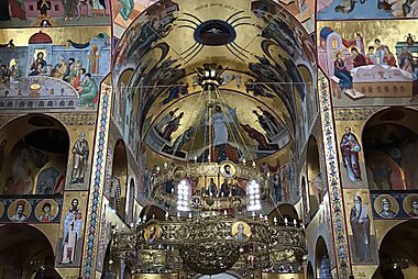



Cathedral of the Resurrection of Christ, Podgorica is the largest Orthodox cathedral in the region and the city's most recognizable landmark, consecrated in 2013 after about two decades of construction. Its gilded interior and bell tower dominate the skyline west of the river.
Millennium Bridge is Podgorica's signature modern structure, a cable-stayed bridge that has become the symbol of the rebuilt, post-independence city. It is especially striking lit up after dark.
Doclea preserves the remains of a Roman provincial capital, with a forum, basilica, and city walls still visible on a plateau above the Zeta river. It gets far fewer visitors than its historical importance deserves.
King Nikola's Palace was the 19th-century winter residence of King Nikola I and now houses the Center for Contemporary Art of Montenegro inside its original rooms and gardens.
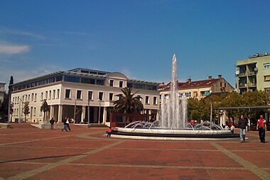
Independence Square is the city's central square and civic heart, home to the state art gallery and the city library, and a good starting point for exploring the Nova Varoš district on foot.
Clock Tower is one of the few Ottoman-era structures to survive intact, marking the edge of the old Stara Varoš quarter.
Dajbabe Monastery is a working monastery built into a natural cave on the edge of the city, with frescoes painted directly onto the rock by its founder.
Öne Çıkan Listeler


Majestic Mountains and Peaks
This collection features the rugged limestone topography of the Kuči region and the Cijevna River canyon. Highlights include the dramatic Grlo Sokolovo, a cliff edge offering views into the 1,000-meter deep Cijevna canyon and the Prokletije massif. The list spans from the low-lying hills of Hum near Lake Skadar to high-altitude border peaks like Maja Suka e Lakut, showcasing the transition from Mediterranean karst to alpine terrain.
20 yer
Notable Religious Sites
This collection highlights the diverse spiritual landscape of Podgorica and its surroundings, ranging from the monumental, modern Cathedral of the Resurrection of Christ to historic Ottoman-era landmarks like the 15th-century Starodoganjska Mosque. The list includes the striking brutalist architecture of the Church of the Sacred Heart of Jesus and several secluded Orthodox monasteries, such as Vranjina on Skadar Lake and the cliffside Piperska Ćelija. These sites represent the long-standing coexistence of Orthodox, Catholic, and Islamic traditions through distinct architectural styles.
17 yer
Neler deneyimlenmeli
- Watch the traditional high-diving competition off Vizier's Bridge in mid-July, when local divers leap into the Morača in front of crowds along the riverbank.
- Join the evening coffee ritual along the pedestrian streets around Hercegovačka, where locals linger over a single small coffee for an hour or more.
- Taste Vranac and other Montenegrin wines at the Plantaže estate on the city's southern edge, one of the largest single vineyards in Europe.
- Cycle or walk the riverside path along the Morača in the evening, when the promenade fills with locals and the modern skyline lights up.
Turlar ve Aktiviteler
Podgorica — Harita

 Etkileşimli haritayı aç
Günübirlik geziler
Podgorica sits close to Montenegro's main attractions, so a short trip out of the city is easy to arrange by car, bus, or organized tour.
- Lake Skadar — ≈30–45 min by car to Virpazar. The Balkans' largest lake is a national park known for pelicans and boat trips through reed-lined channels.
- Cetinje — ≈40 min by car or bus. Montenegro's former royal capital, with the national museum, several foreign-embassy buildings from the kingdom era, and Cetinje Monastery.
- Ostrog Monastery — ≈1–1.5 h by car. A Serbian Orthodox monastery built into a sheer cliff face, one of the most important pilgrimage sites in the Balkans.
- Budva — ≈1 h by car. A walled old town on the Adriatic coast, backed by beaches and a lively summer nightlife scene.
- Kotor — ≈1.5 h by car through the Sozina tunnel. A UNESCO-listed old town at the head of a fjord-like bay, ringed by fortified walls climbing the mountainside.
Nereyi keşfetmeli
Lake Skadar National Park makes up much of the countryside south of the city and is the easiest nature escape from Podgorica, with wetlands, vineyards, and lakeside villages. At its heart lies Lake Skadar, the largest lake in the Balkans and a major stop for migratory birds.
Nasıl gidilir
- By air: Podgorica Airport (TGD) is the country's main international gateway, about 12 km south of the center. A taxi into town takes around 20 minutes; the airport's own rail halt runs too infrequently to be practical, so a taxi or pre-booked transfer is the way most travelers arrive. Tivat Airport, on the coast, is about 1.5 hours away and mainly serves seasonal charter flights.
- By train: The main railway station connects Podgorica to Bar on the coast in around an hour, and north to Belgrade in Serbia on the scenic Belgrade–Bar line, a well-known ride through mountain viaducts and tunnels.
- By bus: The main bus station has frequent long-distance coaches to every Montenegrin coastal town, plus international connections to Serbia, Bosnia and Herzegovina, and Albania.
Ulaşım
- Public transit: City buses cover the main routes; buy your ticket in cash from the driver when boarding, since contactless payment is not yet standard on board.
- Taxi: Taxis are inexpensive by European standards; ask the driver to use the meter or agree the fare before setting off.
- On foot / cycling: The center is flat and compact, so walking covers most of the top sights. A riverside path along the Morača is popular for cycling and running.
Araç kullanımı
- Is a car worth it?: Not for the city center itself, which is small and walkable, but a car is the most flexible way to reach Lake Skadar, Cetinje, and the coast in a single day.
- Parking: Metered street parking (marked by color-coded zones) covers most of the center; pay by SMS or at a nearby machine. Free parking is easier to find a short walk from downtown.
- Restrictions: There is no congestion charge or low-emission zone in Podgorica.
Yeme ve içme
Podgorica sits inland, so the food leans toward grilled meat, river fish, and mountain specialties rather than seafood. Look for lamb or veal cooked ispod sača, under a metal dome buried in embers, and freshwater trout or carp from the rivers and Lake Skadar.
For a concentration of restaurants and cafés, head to the pedestrian streets around Hercegovačka and the Stara Varoš quarter, where traditional Montenegrin taverns sit alongside modern bars and coffee houses.
Güvenlik ve sağlık
Podgorica is a safe city for travelers, with very little violent crime. The main risks are ordinary ones: pickpocketing in crowded markets and overcharging by unmetered taxis, so agree the fare or ask for the meter before you get in.
Tap water in the city is generally safe to drink, though bottled water is cheap and widely available if you prefer it.
Tarihçe
Podgorica's history goes back to Roman times: Doclea was a provincial capital of the Roman Empire, and the settlement continued through Slavic and Ottoman rule under a series of names. The Ottomans held the town for over four centuries, leaving behind the Clock Tower and the old Vizier's Bridge crossing in the Stara Varoš quarter.
After Montenegro joined the Kingdom of Serbs, Croats and Slovenes in 1918 and later socialist Yugoslavia, the city was heavily bombed in the Second World War and largely rebuilt. It was renamed Titograd in 1946 in honor of Yugoslav leader Josip Broz Tito, and only reverted to its original name, Podgorica, in 1992. It became the capital of an independent Montenegro after the 2006 referendum.
Ülke bilgileri
Quick practical facts for Montenegro at a glance:
- Para birimi
- Euro EUR · Kartla ödeme · Genellikle kabul ediliyor
- Acil durum numaraları
- 112
- Elektrik
- 230 V · 50 HzTip C / Tip F
- Musluk suyu
- Dikkatli için
- Trafik akış yönü
- Sağ
- Ülke kodu
- +382


Podgorica – Günlerini Planla
Bu rehberdeki yerleri; akıllı rota oluşturma, tahmini süreler ve kusursuz bir gezi için gereken her şeyle gerçek bir güzergaha dönüştür.


İlgili varış noktaları


Data: © OpenStreetMap contributors, Wikidata, Wikipedia, Tripomatic, Official websites, geoBoundaries (CC BY 4.0). Tours by GetYourGuide. We earn commission from bookings. Travel guide generated with AI.