


Аппенцелль
Appenzell is a small village in northeastern Switzerland, below the Alpstein mountains. The main street has brightly painted houses with flower boxes and carved signs. Farms and meadows surround it.
The village is the capital of the half-canton of Appenzell Innerrhoden. It is known for traditional customs, cheese and hiking. Most visitors come for a day or a few nights.

Аппенцелль — Плануєш подорож?
Створи свій щоденний маршрут у додатку Tripomatic.


Коли їхати
June to September is the best time for hiking and the high cable cars. Spring brings flowers and fresh green meadows. Autumn is clear and has the cattle processions when herds come down from the mountains. Winter is snowy and cold, and some mountain paths close. On the last Sunday of April, citizens vote in the open air at the Landsgemeinde.
Головні пам'ятки




- Säntis is the highest peak in the Alpstein. A cable car climbs from Schwägalp, and the summit has views of six countries on a clear day.
- Ebenalp is reached by cable car from Wasserauen. Trails lead to the cave church and a cliff-side inn.
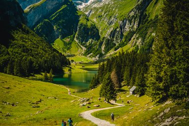
- Seealpsee is a mountain lake reached by a walk of about 1 hour from Wasserauen.
- Pfarrkirche St. Mauritius is the village church, with a painted interior.
- Brauerei Locher is a local brewery with a visitor centre.
- Museum Appenzell tells the story of local customs and crafts.
- Kunstmuseum Appenzell shows art in a modern building.
- Klosterkirche is a small church in the village.
Цікаві добірки

Що варто спробувати
- Walk the painted main street and look at the carved signs.
- Ride the cable car to Ebenalp and walk to the cave church.
- Walk to Seealpsee and swim or rest at the lake.
- Ride to the Säntis summit for views.
- Visit the brewery and taste local beer.
- Hike on marked trails in the Alpstein hills.
Екскурсії та активності
Аппенцелль — Карта

Одноденні поїздки
- Wasserauen is about 15 minutes away by train. It is the start of the paths to Ebenalp and Seealpsee.
- Schwägalp, the base of the Säntis cable car, is reached by bus and takes about 1 hour.
- St. Gallen is about 50 minutes away by train.
- Lake Constance is about 1 hour away.
Як дістатися
- By air: Zurich Airport is the nearest main airport. The trip takes about 2 hours by train.
- By train: Appenzell is on a narrow-gauge line from St. Gallen. Check times on SBB.
- Trains also run on to Wasserauen.
Транспорт і пересування
- The village is small and easy to walk.
- Local trains and buses reach the mountain stations.
- The cable cars to Ebenalp and Säntis run all year, with breaks for maintenance.
- Hiking paths link the village to nearby farms and hills.
Водіння авто
- A car is not needed in the village. Public transport reaches the mountain stations.
- Parking in the village is limited at busy times.
- Mountain roads can be steep and narrow.
Їжа та напої
Try Appenzeller cheese, a strong cheese ripened in herb brine. Appenzeller Biberli are filled gingerbread. Local sausages and dried meats are common. The herbal liqueur Alpenbitter comes from the area.
The region keeps old customs, such as yodelling, folk music and the Landsgemeinde. Local people speak a distinctive German dialect.
Безпека й здоров'я
- Appenzell is very safe.
- Mountain weather can change fast. Check the forecast before any hike.
- Wear good boots on trails. Paths can be wet and steep.
- Tap water is safe to drink.
Історія
Appenzell grew around an abbey of St. Gall. The area joined the Swiss Confederation in 1513. The region later split into two halves, Innerrhoden and Ausserrhoden, over religion in 1597.
Innerrhoden stayed Catholic, and the village kept its customs. Today it is a small canton with a strong local identity.
Факти про країну
Quick practical facts for Switzerland at a glance:
- Валюта
- швейцарський франк CHF CHF · Оплата карткою · Приймаються майже всюди
- Номери екстрених служб
- 112
- Електроенергія
- 230 В · 50 ГцТип C / Тип J
- Мови
- німецька, французька, італійська, ретороманська
- Водопровідна вода
- Безпечна для пиття
- Сторона руху
- Праворуч
- Телефонний код
- +41


Аппенцелль — Сплануй свої дні
Перетвори місця з цього путівника на справжній маршрут із розумною навігацією, розрахунком часу та всім необхідним для ідеальної подорожі.


Схожі напрямки
Data: © OpenStreetMap contributors, Wikidata, Wikipedia, Tripomatic, Official websites, geoBoundaries (CC BY 4.0). Tours by GetYourGuide. We earn commission from bookings. Travel guide generated with AI.
Плануй подорож разом із Tripomatic
- Планування на основі ШІДозволь ШІ побудувати твій маршрут, відповісти на запитання про поїздку та впорядкувати бронювання.
- Сповіщення для мандрівниківОфіційні попередження, негода, страйки та природні небезпеки для місць на кожен день подорожі.
- Державні свята та подіїДізнавайся про свята, фестивалі та вихідні в дні твоєї поїздки та про те, як вони можуть вплинути на плани.
- Оцінка витратРозрахунок витрат на поїздку за допомогою ШІ допоможе заздалегідь визначити бюджет.
- Екскурсії та квиткиБронюй екскурсії, квитки без черги та цікаві активності просто у своєму плані.