


هالشتات
Hallstatt is a small village on the western shore of Lake Hallstatt, squeezed between the water and steep mountain walls. It is a UNESCO World Heritage site and one of the most photographed places in Austria. Salt mining here goes back more than 7,000 years.
The village is tiny and busy in high season. Come early or stay overnight to see it calm. Many visitors also use it as a base for the wider Salzkammergut lake region.

هالشتات – هل تخطط لرحلة؟
أنشئ خط سير رحلتك يوماً بيوم في تطبيق Tripomatic.


أفضل وقت للزيارة
May to October is the best time for walks, boat trips and mountain views. July and August are the busiest, and day-trip crowds peak at midday. Spring and autumn are quieter, and autumn colours are striking. Winter is cold and quiet, with some attractions closed or on reduced hours. Rain is frequent all year.
أبرز المعالم
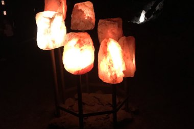
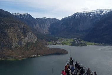


- Salzwelten Hallstatt is one of the oldest salt mines in the world. A funicular climbs to the mine, and the tour includes a miners' slide.
- Hallstatt Skywalk is a viewing platform high above the village, reached by the same funicular.
- Beinhaus is the bone house near the church, with painted skulls.
- Pfarrkirche Maria am Berg is the Catholic church on the slope above the lake.
- Evangelische Kirche Hallstatt is the Protestant church by the water, with a tall tower that appears in many photos.
- Welterbemuseum Hallstatt explains the prehistoric Hallstatt culture and local archaeology.
- Hallstätter Gletscher is the glacier on the Dachstein plateau, reached from Obertraun by cable car.
قوائم مميزة


Christian Heritage Sites
Hallstatt’s religious landscape is defined by its dramatic Alpine setting and centuries of salt-mining history. This collection includes the iconic 19th-century Lutheran church on the lakefront and the late Gothic Catholic Parish Church, known for its 16th-century winged altar. Significant sites extend from the 12th-century ossuary, housing over 1,200 painted skulls, to the Baroque Calvary Hill complex and the high-altitude Dachstein Chapel situated at 2,203 meters near the Simony Hut.
10 أماكن
Dachstein Natural Wonders
The Dachstein Mountains surrounding Hallstatt feature a dramatic karst landscape shaped by ice and water. This selection highlights the region's geological diversity, including the Hallstätter Glacier—the largest in the range—and the Großer Gosaugletscher. The area is home to extensive cave networks like the Hirlatzhöhle and powerful water features such as the 95-meter Waldbachstrub waterfall in the Echerntal valley. These landmarks offer a direct look at the glacial history and alpine topography of the UNESCO World Heritage region.
14 مكاناً
Hallstatt Viewpoints and Peaks
Hallstatt’s landscape is defined by the dramatic interplay between the Hallstätter See and the Dachstein massif. This collection features the Skywalk "World Heritage View," a platform positioned 350 meters above the village, alongside high-altitude peaks like the 2,934-meter Niederer Dachstein and the 2,651-meter Niederes Kreuz. These spots provide vantage points over the UNESCO World Heritage region, ranging from accessible valley views to challenging alpine summits northeast of the Hallstätter Glacier.
6 أماكنتجارب ننصح بها
- Take a boat trip on the lake at sunset or early morning.
- Walk the Salt Trail through the forest above the village.
- Visit the Dachstein ice caves and the 5 Fingers viewing platform from Obertraun.
- Rent a kayak or paddle board on calm days.
- Stay overnight to see the village without the day crowds.
جولات وأنشطة
هالشتات — خريطة

رحلات اليوم الواحد
- Obertraun is the gateway to the Dachstein cable car and ice caves, about 10 minutes away by bus.
- Gosau is a quiet valley with lakes under the Dachstein, about 40 minutes by car.
- Bad Aussee and Altaussee offer lake walks and salt mine tours, about 40 minutes by car.
- Bad Ischl is a spa town with the imperial villa, about 30 minutes by car.
- St. Wolfgang has a pilgrimage church and lake views, about 1 hour by car.
- Salzburg is about 1 hour 15 minutes by car or 2 hours by train and bus.
أماكن للاستكشاف
الوصول إلى الوجهة
- By air: The nearest large airports are Salzburg, about 1 hour 15 minutes by car, and Munich, about 3 hours.
- By train: Hallstatt station is across the lake from the village, and a short ferry is timed with the trains. Trains from Attnang-Puchheim connect to the line. Check times on ÖBB.
- By bus: Buses run from Bad Ischl and Salzburg during the season.
- By car: Cars are not allowed in the village centre for most visitors. Use the large car parks at the entrance. They fill early in summer.
التنقل والمواصلات
The village is small and best on foot. Lanes are steep and cobbled. A funicular takes you to the salt mine. Boats cross the lake and make short trips. Ferry and bus connections link the village to the station and nearby towns.
القيادة
Parking is limited and strictly managed. Park at the entrance car parks and walk in. The road along the lake is narrow and busy at peak times. Public transport and the lake ferry are often easier than driving.
المأكولات والمشروبات
Fresh lake fish, especially char and trout, are local favourites. Try Kaiserschmarrn and apple strudel in the village cafes. Salt from the mines appears in local gifts. Restaurants cluster around the market square, and prices are higher than elsewhere in the region.
السلامة والصحة
Hallstatt is safe. The main risk is crowding on narrow lanes and wet cobbles. Weather in the mountains changes quickly, so check forecasts before going up. Tap water is clean and safe to drink. The emergency number is 112.
التاريخ
People mined salt in Hallstatt more than 7,000 years ago. The Hallstatt culture of the early Iron Age is named after the finds from the cemetery above the village. Salt remained the economic base for centuries. The area was listed as a UNESCO World Heritage site in 1997 as the Hallstatt-Dachstein Salzkammergut cultural landscape.
حقائق عن البلد
Quick practical facts for Austria at a glance:
- العملة
- يورو EUR € · الدفع بالبطاقات · مقبولة بصورة شائعة
- أرقام الطوارئ
- 112
- الكهرباء
- 230 فولت · 50 هرتزالنوع C / النوع F
- اللغات
- الألمانية
- مياه الصنبور
- صالحة للشرب
- جهة القيادة
- اليمين
- رمز الاتصال الدولي
- +43


هالشتات – خطط لأيامك
حوّل الأماكن المذكورة في هذا الدليل إلى خط سير حقيقي، مع ملاحة ذكية وتقديرات زمنية وكل ما تحتاجه لرحلة مثالية.


وجهات ذات صلة
Data: © OpenStreetMap contributors, Wikidata, Wikipedia, Tripomatic, Official websites, geoBoundaries (CC BY 4.0). Tours by GetYourGuide. We earn commission from bookings. Travel guide generated with AI.
خطط لرحلتك مع Tripomatic
- تخطيط مدعوم بالذكاء الاصطناعيدع الذكاء الاصطناعي يبني خط سير رحلتك، ويجيب عن أسئلة السفر، ويُدرج مستندات حجوزاتك داخل رحلتك.
- تنبيهات السفرإرشادات رسمية، وتحذيرات الطقس القاسي، والإضرابات، والمخاطر الطبيعية للأماكن المجدولة في كل يوم من رحلتك.
- العطلات الرسمية والفعالياتتعرف على العطلات والمهرجانات وأوقات الإغلاق خلال أيام رحلتك، وتأثيرها على خططك.
- تقدير التكاليفتفصيل تكاليف الرحلة مدعوم بالذكاء الاصطناعي لتعرف الميزانية المناسبة قبل انطلاقك.
- جولات وتذاكراحجز الجولات وتذاكر تجاوز طوابير الانتظار والأنشطة مباشرة من داخل خطتك.