


El Hierro
El Hierro is the westernmost and southernmost of the Canary Islands. It is a quiet volcanic island with steep cliffs, pine and laurel forests, and black lava coasts. Only about 11,700 people live here. It is a UNESCO Biosphere Reserve and a UNESCO Global Geopark.
The island suits walkers, divers and travelers who want calm. There are no big resorts. Days are spent on trails, in natural sea pools and in the clear water near La Restinga. You need three or more nights to see the island at a relaxed pace.

El Hierro – Planst du eine Reise?
Erstelle deine Reiseroute Tag für Tag in der Tripomatic-App.


Beste Reisezeit
El Hierro is mild all year. Summer is dry and sunny. Most rain falls from November to March, and the central highlands are often in cloud. The trade winds are strong on the high western plateau.
The biggest event is the Bajada de la Virgen de los Reyes. It is held every four years, starting on the first Saturday of July, and the next one is in 2029. The statue of the Virgin is carried across the island to Valverde. Book flights and rooms far ahead if you plan to come.
Beste Reisezeit: Januar, Februar, März, April, Mai, Juni, Juli, August, September, Oktober, November, Dezember
Top-Sehenswürdigkeiten


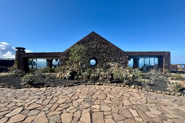
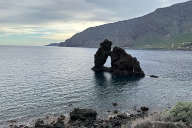
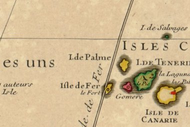
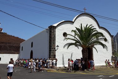
- Garoé is the home of the island's sacred tree. The Bimbache, the first islanders, collected water from the tree and from pools around it. Today a replanted tree stands here with an interpretation centre.
- Mirador de la Peña is a viewpoint on the north side of the island.
- El Sabinar is a juniper forest in La Dehesa. The wind has bent the trees almost flat. Some of the best trees are fenced off to protect them.
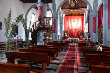
- Santuario Insular de Nuestra Señora de los Reyes is the chapel of the island's patron, the Virgen de los Reyes. It is where the Bajada festival procession begins.
- Faro de Orchilla is a lighthouse on the far western tip, built in the early 20th century.
- Monumento al Meridiano Cero marks the old Ferro meridian near the lighthouse. Until 1884 maps used this island as the zero line of longitude.
- Charco Azul is a natural sea pool in the El Golfo area.
- Piscinas Naturales de La Maceta has several natural pools.
Empfohlene Listen


Volcanic Landscapes of El Hierro
El Hierro is the youngest of the Canary Islands, shaped by intense volcanic activity and massive prehistoric landslides. This collection features the island's geological highlights, including the 1,501-meter Pico de Malpaso and the Tanganasoga cinder cone which dominates the El Golfo valley. The landscape includes sheer coastal cliffs like the iconic Roque de La Bonanza and numerous dormant craters that illustrate the island's shield volcano origins and more recent submarine eruptions near La Restinga.
11 Orte

Erlebnisse & Aktivitäten
- Dive in the marine reserve at La Restinga. The Mar de las Calmas reserve has several dive points, including El Bajón and Punta Restinga. The seabed changed after the 2011 submarine eruption. Dive schools in La Restinga teach beginners.
- Swim in the natural pools. Lava pools such as Charco Azul and Piscinas Naturales de La Maceta fill with sea water. Cala de Tacorón, near La Restinga, has calm water.
- Walk the Ruta del Agua. This circular trail starts near Garoé. It goes through laurel forest and past old pools and viewpoints.
- Hike the Camino de Jinama. The trail starts at the church in Frontera. It is hard, and cliff paths can have landslides, especially in wind and rain.
- Walk the El Sabinar loop. This circular route starts at the chapel of the Virgen de los Reyes.
- Join the Bajada. Every four years the island celebrates the Virgin of the Kings for about a month. Other fiestas include San Juan in La Restinga (around 23 June) and San Lorenzo in El Golfo (August).
Touren & Aktivitäten
El Hierro — Karte

 Interaktive Karte öffnen
Orte zum Entdecken
Other Canary Islands are reached by ferry or plane, usually through Tenerife or Gran Canaria.
- La Gomera and La Palma are the nearest islands.
- Hubs for connections: Tenerife and Gran Canaria.
Anreise
El Hierro has no direct flights or ferries from mainland Spain or Europe. You connect through Tenerife or Gran Canaria.
- By air: El Hierro Airport (VDE) is in the north-east, about 9 km from Valverde. Binter Canarias flies from Tenerife North and Gran Canaria. CanaryFly also flies from Tenerife North. The short runway takes only turboprop planes.
- Airport to Valverde: A taxi is the simplest way to reach town.
- By ferry: Fred. Olsen Express sails from Los Cristianos on Tenerife to the port of La Estaca, near Valverde. The crossing takes about 2 hours 20 minutes. The port is under 15 minutes by road from Valverde, and a bus stop connects to town. Fred. Olsen Valverde terminal
- Boarding: foot passengers must board 20 minutes before departure, and cars 40 minutes before.
Unterwegs vor Ort
The island is about 40 km long and very hilly. A car is the easiest way to see it.
- Bus: TransHierro runs the island buses. Coverage is limited, so check the timetable first. TransHierro
- Taxi: Taxi ranks are in Valverde, Tigaday and La Restinga.
- Hiking: Trails are the best way to see the forests and cliffs, but villages are far apart.
Autofahren
- Is a car worth it? Yes, for most visits. The west and the mountains have no bus service. Car rental is available at the airport, so book ahead.
- Ferry: Cars can be taken on the Fred. Olsen ferry from Tenerife. Vehicles must board 40 minutes before departure.
Essen & Trinken
Cheese is part of almost every local dish. Try quesadilla herreña, a sweet cheese and aniseed pastry, and the cheese soup (caldo de queso).
Fish is the main dish on the coast. La Restinga is known for fresh fish and limpets. El Hierro has its own wine denomination, mostly full-bodied white wines.
Sicherheit & Gesundheit
El Hierro is a safe, quiet island. Petty crime is rare.
- Sea: Natural pools are usually not supervised. Swell can change quickly, so check the sea before you swim.
- Trails: Cliff trails such as the Camino de Jinama carry a landslide risk, higher in wind and rain. Weather can change fast in the highlands.
- Emergencies: call 112.
Geschichte
The Bimbache were the first people on the island. They drew water from the Garoé tree. A hurricane felled the tree in 1610, and a new tree was planted near Garoé later.
For centuries El Hierro was seen as the western edge of the known world. Its meridian, the Ferro meridian, was a map reference until Greenwich was adopted in 1884. See it at Monumento al Meridiano Cero.
The Bajada festival began with a vow made in the 18th century to the Virgen de los Reyes, honoured at Santuario Insular de Nuestra Señora de los Reyes. In October 2011 a submarine eruption started about 7 km south of La Restinga and some residents were evacuated for a time.
Länderfakten
Quick practical facts for Spain at a glance:
- Währung
- Euro EUR € · Kartenzahlung · Weitgehend akzeptiert
- Notrufnummern
- 112
- Stromnetz
- 230 V · 50 HzSteckertyp C / Steckertyp F
- Sprachen
- Spanisch
- Leitungswasser
- Trinkbar
- Fahrseite
- Rechtsverkehr
- Telefonvorwahl
- +34


El Hierro – Plane deine Tage
Verwandle die Orte aus diesem Reiseführer in eine echte Reiseroute mit intelligenter Routenführung, Zeitschätzungen und allem für eine perfekte Reise.


Ähnliche Reiseziele


Data: © OpenStreetMap contributors, Wikidata, Wikipedia, Tripomatic, Official websites. Tours by GetYourGuide. We earn commission from bookings. Travel guide generated with AI.