


Kutná Hora
Kutná Hora grew rich on silver starting in the late 13th century. Its mines made the town one of the wealthiest in Central Europe for two centuries, and for a time second only to Prague. That wealth built an extraordinary concentration of Gothic architecture on one small hilltop, and today the whole Historical Town Centre of Kutná Hora, together with the Cathedral of Our Lady at Sedlec in the nearby district of Sedlec, is a UNESCO World Heritage Site.
Kutná Hora is an easy day trip from Prague, about an hour away by train, but it rewards a slower visit too. The old town is compact and walkable, built on a steep ridge above the Vrchlice river. Narrow lanes run past mining-era burgher houses to a cathedral with the scale of a much bigger city. It suits travelers who want serious history and architecture without a big-city pace.

Kutná Hora – Planst du eine Reise?
Erstelle deine Reiseroute Tag für Tag in der Tripomatic-App.
Beste Reisezeit
Spring and autumn are mild and the best seasons for a full day exploring the old town on foot. Summer is warm and busy with day-trippers, and winter is cold with regular snow but far quieter.
Plan around the Královské stříbření Kutné Hory (Royal Silvering of Kutná Hora), a weekend festival held every June with costumed processions, jousting and market stalls that reenact the town's medieval mining heyday.
Beste Reisezeit: Juni, August, September
July and August afternoons can bring short thunderstorms, and the main square gets a small Christmas market in December.
Top-Sehenswürdigkeiten
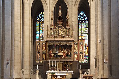

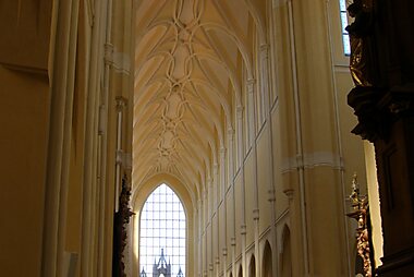
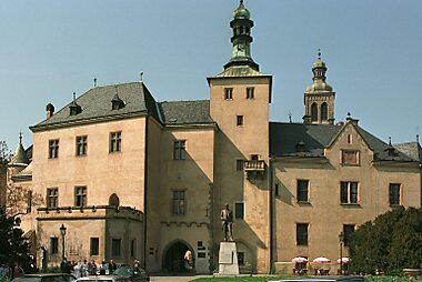
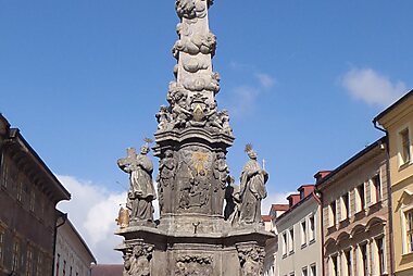
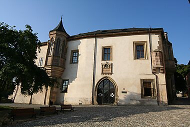

St. Barbara's Church is Kutná Hora's defining landmark, a soaring Gothic cathedral begun in 1388 and funded by the town's silver miners' guild. Its ribbed vaults, flying buttresses and stained glass are worth a full hour inside.
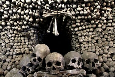
North of the centre in Sedlec, Sedlec Ossuary (Kostnice) is a small chapel decorated with the bones of tens of thousands of people. The woodcarver František Rint arranged them into chandeliers, garlands and a coat of arms in 1870. It is one of the most visited sights in the country, so arrive early or book a timed slot to skip the queue.
Nearby, Cathedral of Our Lady at Sedlec is a Gothic and early Baroque church built for the Cistercian monastery at Sedlec, and one of the most influential buildings of its kind in Bohemia.
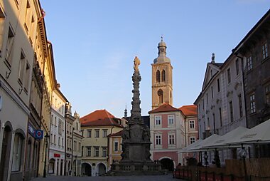
On the main square, Italian Court was once the royal mint where the Prague groschen was struck. It later served as a part-time royal residence, and its chapel and old mint workshops are open to visitors.
Next to it, the roughly 80-metre Gothic tower of Saint James Church, built between the 1330s and 1420, has dominated the skyline for centuries.
The Czech Museum of Silver tells the story of the silver rush across several historic buildings. Its underground circuit lets you walk a real medieval mine shaft wearing a miner's coat.
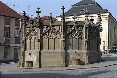
Part of the same museum, Stone House is a late Gothic burgher house with an elaborately sculpted facade, one of the finest in town.
Housed in the former Jesuit college above the river, Gallery of Central Bohemian Region (GASK) shows modern and contemporary Czech art inside a Baroque building with peaceful garden grounds.
Empfohlene Listen


Best Viewpoints & Towers
Kutná Hora's landscape is defined by its medieval skyline and the surrounding Malešovská pahorkatina hills. This selection includes the Havířská bouda observation tower on Kaňk hill, standing at 353 meters, and historical bell towers in the city center. Natural viewpoints like the Denemark hillfort offer vistas of the Vrchlice valley, while the modern Menhir provides a specific perspective of St. Barbara’s Cathedral and the Jesuit College.
5 OrteAudioguides – Kutná Hora
Erkunde die Stadt zu Fuß mit einer selbstgeführten Audiotour, die dir jeden Ort erklärt, sobald du ihn erreichst.


Höre die Audiotouren von Kutná Hora
1 Rundgang in Audioguides von Tripomatic


Erlebnisse & Aktivitäten
- Put on a miner's coat and helmet for the underground circuit at the Czech Museum of Silver, walking real medieval mining passages beneath the town.
- Time a visit for the Královské stříbření Kutné Hory festival in June, when the old town fills with medieval costumes, a market and mock jousting.
- Walk or cycle the wooded Vrchlice valley just below the old town, past a small waterfall, for a break from cobbled streets.
Touren & Aktivitäten
Kutná Hora — Karte

 Interaktive Karte öffnen
 Tagesausflüge
Kutná Hora sits close to a few worthwhile towns and castles of its own, and it also works well as a day out from the capital in the other direction.
- Kolín — a historic river town about 15 minutes away by train, with its own Gothic church and a walkable old town.
- Čáslav — a small town roughly 20 minutes away by train or car, with a Gothic church where the Hussite general Jan Žižka was buried (his tomb was later destroyed, but the church still marks the spot).
- Žleby Chateau — an English neo-Gothic castle about 20 minutes by car, with period interiors and landscaped gardens; bus connections are less frequent.
- Prague — the Czech capital is about an hour away by train. Most Kutná Hora day-trippers come from there, but the trip works just as well in reverse.
Anreise
- By air: the nearest airport is Václav Havel Airport Prague, about 90 minutes by car; nearly all visitors arrive via Prague.
- By train: direct trains from Prague's main station (Praha hlavní nádraží) take as little as 51 minutes, typically just over an hour. They stop at Kutná Hora hlavní nádraží, about 2 km from the old town. A short connecting train continues to Kutná Hora město station, right by St. Barbara's Church.
- By bus: regional coaches run from Prague several times a day and take a bit longer than the train, with a stop closer to the town centre than the main train station.
Unterwegs vor Ort
- On foot: the old town is compact but hilly — steep lanes climb between the main square and St. Barbara's Church. Comfortable shoes help.
- Local train: a short shuttle service connects Kutná Hora hlavní nádraží, the town centre (Kutná Hora město) and Sedlec, so you don't have to walk between the cathedral, the ossuary and the historic core.
- Taxi: useful for the short hop out to Sedlec if you'd rather not wait for the connecting train.
Autofahren
- Is a car worth it?: not for the old town itself — everything is walkable and the historic core is largely pedestrianized. A car helps if you're combining Kutná Hora with Žleby Chateau or other countryside stops.
- Parking: paid car parks ring the edge of the old town, including near Italian Court and the bus station; street parking in the centre is limited.
- Motorway: part of the fastest route from Prague uses a Czech motorway, so check whether you need an e-vignette before you set off.
Essen & Trinken
Restaurants and cafés cluster around Palackého náměstí, the main square, and along Šultysova street leading up toward St. Barbara's Church. It's a good stretch for a sit-down lunch after sightseeing.
Kutná Hora doesn't have a food scene distinct from the rest of Bohemia, so expect the same hearty, meat-and-dumpling classics found across the country.
Sicherheit & Gesundheit
Kutná Hora is very safe for travelers, with petty crime rare even in the busiest months. Keep an eye on belongings in the queues and crowds at Sedlec Ossuary (Kostnice) and St. Barbara's Church during peak season. Pickpocketing is more likely there than anywhere else in town.
The old town's cobbled lanes are steep and uneven in places, so wear sturdy shoes, especially after rain or snow.
Geschichte
Silver was discovered here in the late 13th century, and the boomtown that followed briefly rivaled Prague in wealth. King Wenceslas II centralized the kingdom's coinage at the Italian Court. The Prague groschen was struck here for generations, funding much of medieval Bohemia's expansion.
That silver money paid for the town's outsized churches. Construction of St. Barbara's Church began in 1388, financed by the miners' guild. Silver income was unpredictable, though, and building dragged on for more than five centuries — it was only finished in 1905. The mines were exhausted by the 18th century, and the town's fortunes declined with them. That decline left its medieval core largely untouched by later development.
At Cathedral of Our Lady at Sedlec in Sedlec, the Cistercian abbot Henry is said to have scattered soil from Jerusalem's Golgotha over the adjoining cemetery in 1278. That act made it one of Central Europe's most sought-after burial grounds. Centuries later, the bones exhumed to make room for new graves decorated the Sedlec Ossuary (Kostnice). The chapel is now known worldwide as the Bone Church.
Both the town's historic centre and the church at Sedlec were added to the UNESCO World Heritage List in 1995.
Länderfakten
Quick practical facts for the Czech Republic at a glance:
- Währung
- Tschechische Krone CZK Kč · Kartenzahlung · Häufig akzeptiert
- Notrufnummern
- 112
- Stromnetz
- 230 V · 50 HzSteckertyp C / Steckertyp E
- Sprachen
- Tschechisch
- Leitungswasser
- Trinkbar
- Fahrseite
- Rechtsverkehr
- Telefonvorwahl
- +420


Kutná Hora – Plane deine Tage
Verwandle die Orte aus diesem Reiseführer in eine echte Reiseroute mit intelligenter Routenführung, Zeitschätzungen und allem für eine perfekte Reise.




