


גראן קנריה
Gran Canaria is a round volcanic island in the middle of the Canary archipelago. Its landscapes change a lot in a short drive. The south is dry and sunny, with golden dunes and the big beach resorts. The north is greener, with banana farms and old colonial towns. The centre rises to steep pine-covered mountains and deep ravines.
The island suits several kinds of trip. Many visitors come for a beach week around Maspalomas and Playa del Inglés. Others base themselves in Las Palmas de Gran Canaria, a busy port city with a historic old quarter and a long urban beach. Hikers and cyclists come for the mountain interior, which is less than an hour's drive from the coast.

גראן קנריה – מתכנן טיול?
בנה את המסלול היומי שלך באפליקציית Tripomatic.


מתי לבקר
Gran Canaria is warm all year, so there is no bad season for a beach trip. Winter is mild and popular with northern Europeans, while summer is hot and dry in the south. The north and the mountains are cooler and cloudier than the southern resorts, and the summit area can be cold at night in winter.
Plan around the Las Palmas Carnival if you can. It fills the capital with parades, costumes, music and street parties for several weeks before Lent, usually in February.
הזמן הטוב ביותר לביקור: ינואר, פברואר, מרץ, אפריל, מאי, יוני, יולי, אוגוסט, ספטמבר, אוקטובר, נובמבר, דצמבר
אטרקציות מובילות
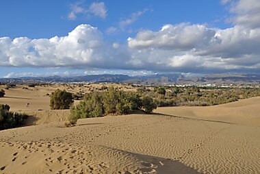



Las Dunas de Maspalomas are a protected field of sand dunes next to the southern resorts. Walk across them on the marked paths to the beach and the lagoon near Faro de Maspalomas.
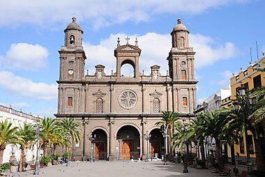
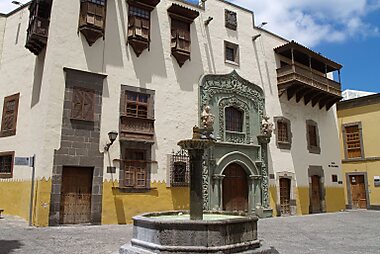
Vegueta is the old colonial quarter of Las Palmas, with stone streets, wooden balconies and quiet squares. Here you find Catedral de Santa Ana, whose tower has a lift to a viewpoint, and Casa de Colón, a museum about Columbus and the islands' links with the Americas.
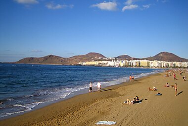
Playa de Las Canteras is the city's long urban beach. A natural reef offshore calms the water, so swimming and snorkelling are easy on most days.
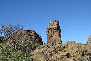
Roque Nublo is a huge basalt rock on a high ridge and the symbol of the island. A short, steep trail leads to its base, with views to Tenerife's Teide on clear days. Book a time slot online for visits between 9:00 and 17:00. There is no parking at the trailhead, so take the shuttle bus from Cruz de los Llanos or Tejeda.
Roque Bentayga is a rock tower above the Tejeda valley that was a sacred site for the island's first people. It is part of the UNESCO-listed cultural landscape of Risco Caído and the Sacred Mountains.
Puerto de Mogán is a small harbour in the southwest with white houses, flowers and narrow canals. It is calmer and prettier than the big resorts.
Basílica de Nuestra Señora del Pino in Teror is the island's most important church, home of its patron saint. The streets around it have some of the best traditional wooden balconies on the island.
Museo y Parque Arqueológico Cueva Pintada in Gáldar protects a cave with red, black and white geometric paintings. The island's pre-Hispanic people made them, and the remains of their village surround the cave.
רשימות מומלצות


Gran Canaria Markets
Gran Canaria’s markets range from historic 19th-century food halls in Las Palmas to traditional Sunday gatherings in the central highlands. The city markets of Vegueta and Mercado Central offer extensive selections of Canarian produce, fresh Atlantic seafood, and tropical fruits. In the mountain villages of Teror and San Mateo, weekly markets specialize in regional delicacies including artisanal cheeses, honey, and the famous soft chorizo de Teror, often set against the backdrop of historic colonial architecture.
5 מקומותחוויות מומלצות
- Watch the stars from the summit. The high centre of the island is above most clouds and far from city lights, and guided stargazing tours run on clear nights.
- Take a surf lesson in the city. La Cícer, the southern end of Las Canteras beach, has steady waves and several surf schools.
- Watch the windsurfers at Pozo Izquierdo. Strong, steady winds on the southeast coast bring top riders here, and a world cup event takes place every summer.
- Join the Fiesta de la Rama. Every August in Agaete, crowds dance through the streets waving tree branches, then beat them on the sea to call for rain.
- Take a boat trip to see dolphins. Boats from the southern harbours go out to look for dolphins and pilot whales in the deep water off the coast.
סיורים ופעילויות
גראן קנריה — מפה

טיולי יום
Gran Canaria sits in the centre of the Canary Islands, so a neighbouring island makes a good day out. Take an early ferry to make the most of the day.
- Tenerife — ≈1 h 20 min by fast ferry from Agaete to Santa Cruz de Tenerife, or a short flight. Spain's highest peak, Teide, and the historic town of La Laguna are the main draws.
- Fuerteventura — ≈2–3 h by ferry from Las Palmas de Gran Canaria to Morro Jable in the south of the island, or a short flight. It makes a long day, so check return times first. The island has long white-sand beaches and wide, quiet landscapes.
היכן לטייל
On Gran Canaria
- Las Palmas de Gran Canaria — the largest city of the Canary Islands. It shares the role of regional capital with Santa Cruz de Tenerife and has the old Vegueta quarter and Las Canteras beach.
- San Bartolomé de Tirajana — the large southern municipality that includes Maspalomas, Playa del Inglés and the dunes.
Other Canary Islands
- Tenerife — the largest island, built around the volcano Teide.
- Fuerteventura — long white-sand beaches and dunes, the closest island to Africa.
- Lanzarote — dry volcanic landscapes shaped by the work of César Manrique.
- La Gomera — a small, steep island with ancient laurel forest in its high centre.
- La Palma — green and mountainous, with very dark night skies.
- El Hierro — the smallest and quietest of the main islands, good for diving.
איך מגיעים
- By air: Gran Canaria Airport (LPA) is on the east coast, between Las Palmas and the southern resorts. It has frequent flights from across Europe and to the other Canary Islands. Bus 60 goes to Las Palmas de Gran Canaria in about 30 minutes, and bus 66 goes to Playa del Inglés and Maspalomas. Gran Canaria Airport
- By sea: Ferries link the port of Las Palmas with Tenerife, Fuerteventura and Lanzarote. Fast ferries to Santa Cruz de Tenerife also leave from Agaete on the northwest coast. Long ferry crossings connect the island with mainland Spain (Huelva and Cádiz).
איך מתניידים
- Island buses: Blue Global buses (guaguas) connect the airport, Las Palmas, the southern resorts and most villages. You can pay on board in cash or tap a contactless bank card or phone. Frequent riders can save with the rechargeable TransGC card. Global buses
- City buses: Yellow Guaguas Municipales buses cover Las Palmas itself. Guaguas Municipales
- Taxi: Taxis are easy to find at the airport, in Las Palmas and in the resorts.
- On foot and by bike: The old town of Las Palmas, the Las Canteras promenade and the southern resorts are pleasant on foot. The mountain roads are a famous training ground for road cyclists, but they are long and steep.
נהיגה
- Is a car worth it? Not if you only stay in the resorts or in Las Palmas, as buses cover these well. Rent a car if you want to explore the mountain villages and viewpoints, since buses to the interior are slow and infrequent.
- Mountain roads: Roads to Roque Nublo, Tejeda and Artenara are narrow and full of hairpin bends. Drive slowly and allow more time than the map shows.
- Parking: Las Palmas and the resorts use paid blue-zone street parking. Underground car parks are easier in the city centre. Parking at popular viewpoints fills up early, especially at weekends. For Roque Nublo, park at Cruz de los Llanos or in Tejeda and take the shuttle bus to the trailhead.
אוכל ושתייה
Canarian food is simple and based on local produce. Try papas arrugadas, small potatoes boiled in salty water and served with red or green mojo sauce. Gran Canaria is also known for queso de flor, a soft cheese from Guía made with thistle flowers, for fresh fish, and for rum from Arucas. In the mountains, look for almond sweets such as bienmesabe from Tejeda.
For good places to eat, head to the tapas bars around Vegueta in Las Palmas and the food stalls in its central markets. Simple fish restaurants line the harbours of Puerto de las Nieves in Agaete and Arguineguín in the south. In the Barranco de Guayadeque area, you can eat Canarian food in restaurants carved into the rock.
בטיחות ובריאות
Gran Canaria is a very safe destination. The main risk is petty theft, such as bag-snatching on busy beaches, in shopping centres and in crowds during Carnival. Do not leave valuables in a parked car, especially at viewpoints and trailheads.
The Atlantic can be rough, with strong currents on the north and west coasts. Swim only where a green or yellow flag flies, and never under a red flag.
The sun is strong all year, even when it is breezy. In the mountains, the weather can change fast, so carry water and a warm layer. Tap water is safe but comes mostly from desalination plants, so many people prefer bottled water for drinking.
היסטוריה
The first people of Gran Canaria, the Canarii, arrived from North Africa more than 2,000 years ago. They lived in caves and stone houses, farmed the ravines and worshipped on the high mountains. You can still see their world at Museo y Parque Arqueológico Cueva Pintada, at the cliff granaries of Cenobio de Valerón, and on the sacred peak of Roque Bentayga.
Castile began the conquest of the island in 1478, the year Las Palmas was founded in what is now Vegueta. The local people resisted for five years before the island fell in 1483. In 1492, Christopher Columbus stopped here on his first voyage to the Americas, and Casa de Colón tells that story today.
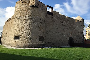
Las Palmas grew rich as a port between Europe, Africa and the Americas. Pirates and enemy fleets attacked it several times, which is why forts such as Castillo de la Luz guard the harbour. Mass tourism arrived in the 1960s, when the resorts of Playa del Inglés and Maspalomas were built next to the southern dunes.
עובדות על המדינה
Quick practical facts for Spain at a glance:
- מטבע
- אירו EUR € · תשלום בכרטיסי אשראי · מקובל באופן נרחב
- מספרי חירום
- 112
- חשמל
- 230 וולט · 50 הרץסוג C / סוג F
- שפות
- ספרדית
- מי ברז
- בטוח לשתייה
- צד הנהיגה
- ימין
- קידומת חיוג בינלאומית
- +34


גראן קנריה – תכנן את הימים שלך
הפוך את המקומות מהמדריך הזה למסלול אמיתי, עם ניתוב חכם, הערכות זמן וכל מה שדרוש לטיול מושלם.


יעדים קשורים


Data: © OpenStreetMap contributors, Wikidata, Wikipedia, Tripomatic, Official websites. Tours by GetYourGuide. We earn commission from bookings. Travel guide generated with AI.
תכנן את הטיול שלך עם Tripomatic
- תכנון מבוסס AIתן ל-AI לבנות את המסלול שלך, לענות על שאלות לטיול ולתייק את מסמכי ההזמנה שלך בתוך הטיול.
- התרעות נסיעהאזהרות רשמיות, מזג אוויר קיצוני, שביתות וסכנות טבע עבור המקומות בכל יום של הטיול שלך.
- חגים ציבוריים ואירועיםצפה בחגים, פסטיבלים וסגירות בימי הטיול שלך, ומה משמעותם עבור התוכניות שלך.
- הערכת עלויותפירוט עלויות טיול מבוסס AI כדי שתדע איזה תקציב לתכנן מראש.
- סיורים וכרטיסיםהזמן סיורים, כרטיסים לעקיפת התור ופעילויות ישירות מתוך התוכנית שלך.