


Bovec
Bovec is a small mountain town in the upper Soča valley, close to the Italian border. Steep peaks surround its wide green basin, and the emerald Soča river flows just below the town. Part of the municipality lies inside Triglav National Park.
This is Slovenia's main base for outdoor sports. Visitors come to raft, kayak and go canyoning on cold, clear water, and to hike to waterfalls, gorges and high passes. The town itself is quiet and practical, with guesthouses, campsites and outdoor agencies rather than grand sights. It suits active travellers and families who want to spend their days outside. Traces of the First World War front line are still visible all around the basin.

Bovec – 旅行を計画中ですか?
Tripomaticアプリで日ごとの旅程を作成しましょう。


ベストシーズン
Late spring and early summer bring melting snow, high water for rafting and the waterfalls at their strongest. July and August are warm and the busiest months, with frequent afternoon storms. September is quieter, with stable weather for hiking and still-warm days. Winter is cold and calm, and the high mountain roads close. The Kanin cable car has been closed since autumn 2023, so there is currently no lift up the mountain and no skiing at Kanin.
The biggest event to plan around is the Soča Valley Hiking & Biking Festival, from early September to mid-October. It offers guided hikes and rides across the valley, including walks along the Soča Trail.
主要観光スポット

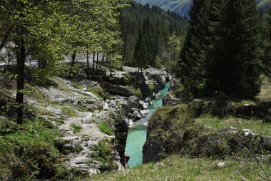


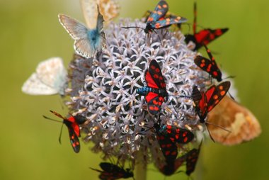
Great Soča Gorge is the most famous stretch of the Soča: a narrow gorge about 750 m long and up to 15 m deep, with clear green water. A marked path follows the rim, and a wooden suspension bridge crosses the river at its start.
Boka Waterfall is one of Slovenia's highest waterfalls, with a main free fall of about 106 m. It is visible from the road west of Bovec, and a 15-minute path leads to a viewpoint. It is most powerful in spring and after heavy rain.
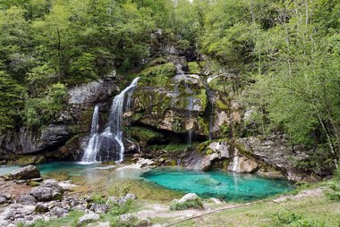
Virje Waterfall is a short walk from the village of Plužna. The water falls about 20 m into a large green pool, which makes it an easy family outing.
Kluže Fortress guards the road at the edge of the deep Koritnica gorge, a few kilometres from town. The present fort dates from 1881–82 and houses an exhibition, and a path climbs to the ruins of Fort Hermann above it.
Mangart Saddle sits at the top of Slovenia's highest road, the Mangart road, at over 2,000 m. Cars currently stop at a car park below the saddle, so the last part is on foot. The views reach across the Julian Alps and down to the Fusine lakes in Italy.
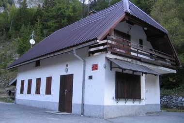
Koča pri izviru Soče marks the start of a short, steep path to the source of the Soča in Trenta. The water flows out of a cave in the rock, about 15 minutes' walk from the hut.
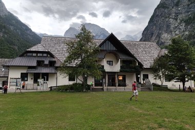
Dom Trenta is the information centre of the national park in the Trenta valley. Its exhibitions cover the park's nature, life in the valley and its mountain guides.
Alpine Botanical Garden Juliana near Trenta is Slovenia's only alpine botanical garden, founded in 1926. It shows plants from the Julian Alps and other mountains and is open from May to September.
Outdoor Museum Ravelnik is a forest trail just outside Bovec through restored First World War trenches, tunnels and shelters. The loop takes about an hour.
注目のリスト


Sacred Sites and Spiritual Landmarks
Explore the diverse spiritual heritage of the Bovec region, ranging from the high-altitude shrines of the Julian Alps to the historic village churches of the Soča Valley. This collection highlights the area's unique history, including the ruins of Slovenia's first mosque built by Bosnian soldiers during World War I, and several Catholic churches that have been reconstructed following the conflicts of the Isonzo Front.
11か所のスポットおすすめの体験
Most visits to Bovec are about the river and the mountains.
- Raft the Soča: Join a guided rafting trip on the cold, clear river between spring and autumn. Agencies provide wetsuits, helmets and transport, and many offer kayaking and hydrospeed too.
- Go canyoning: Slide and jump down natural rock chutes and pools in the side gorges of the valley with a licensed guide.
- Walk the Soča Trail: Follow the river on foot from its source in Trenta towards Bovec, past gorges, suspension bridges and swimming spots. You can walk a single section in a few hours.
- Drive the Mangart road: Take the narrow mountain road with tunnels and hairpins from near Log pod Mangartom towards the Mangart saddle, then walk to the top for wide views. The road is open from late spring to autumn.
- Fly-fish for marble trout: The Soča and its tributaries are famous among anglers for the native marble trout. You need a fishing permit.
- Follow the Walk of Peace: Explore First World War trenches, forts and cemeteries around the basin on this marked route, starting at Outdoor Museum Ravelnik.
ツアー&アクティビティ
Bovec — 地図

日帰り旅行
The Soča valley and the high passes around Bovec make for easy, scenic day trips.
- Trenta valley — ≈20–30 min by car or summer bus. The upper Soča, the Soča source, the national park centre and the alpine garden.
- Log pod Mangartom and the Mangart road — ≈20 min by car to the village, then a climb on Slovenia's highest road. Big mountain views and a short walk to the saddle.
- Kobarid — ≈25 min by car. A small town with an award-winning First World War museum and the Kozjak waterfall nearby.
- Lake Predil and Tarvisio, Italy — ≈30–45 min by car over the Predel pass. A green mountain lake and an Italian market town.
- Tolmin — ≈45 min by car. The Tolmin gorges and the meeting point of the Soča and Tolminka rivers.
- Kranjska Gora — ≈1–1.5 h over the Vršič pass, by car or summer bus. An alpine resort with lakes and easy valley walks.
探索したいエリア
Bovec sits on the edge of Triglav National Park, Slovenia's only national park, which covers the Trenta valley and the high peaks to the east.
Further down the Soča valley are Kobarid and Tolmin. Over the Vršič pass lies the mountain resort of Kranjska Gora.
アクセス方法
- By air: Ljubljana Jože Pučnik Airport and Trieste Airport in Italy are the nearest gateways, each roughly 2 hours away by car. There is no direct public transport from either airport.
- By bus: A few direct buses a day link Bovec with Ljubljana. From 1 June to 30 September, a free bus runs from Kranjska Gora over the Vršič pass to Bovec. A cross-border line also connects Bovec with Tarvisio in Italy over the Predel pass. Arriva bus timetables
- By train: The nearest station is Most na Soči on the Bohinj railway, about 40 km south. Continue by bus via Tolmin or by taxi.
現地での移動
- Summer buses: From June to September, a free bus runs from Bovec up the Soča valley to Trenta, the Soča source and the Vršič pass. Soča Valley tourist board
- Regular buses: Arriva buses link Bovec with Kobarid and Tolmin, but services are infrequent, especially at weekends.
- Outdoor agencies: Rafting, canyoning and hiking providers usually include transport to the river or trailhead.
- On foot and by bike: The town centre is small and easy to walk. Cycling is popular in the flat basin and along the valley, but routes into the mountains are steep.
運転・ドライブ
- Is a car worth it?: Yes, for most visitors. Many sights are spread along the valleys, and public transport is limited outside the summer season.
- Parking: Car parks at popular spots such as the Soča gorges and the Soča source fill early on summer days. Arrive early or use the summer bus.
- Vršič pass: The road to Kranjska Gora climbs to 1,611 m on 50 numbered hairpins and closes in winter. Barriers on both sides control traffic. Passing through is free. Cars may enter the car park at the top only while spaces are free; a display at the barrier shows availability.
- Mangart road: The road is narrow, steep and open only from late spring to autumn. A €10 fee per vehicle is charged at the barrier. Vehicles can currently go only as far as a car park at about km 9, below the saddle; walk the last part.
- Predel pass: The road over the Predel pass to Tarvisio in Italy is the main year-round route north.
グルメ&ドリンク
Bovec's food comes from mountain pastures and the river. Look for Bovec cheese (bovški sir), a hard, slightly spicy sheep's milk cheese with EU protected status. Other local dishes are frika, a pan-fried mix of potatoes, cheese and eggs, and Bovec krafi, sweet dough pockets filled with nuts and raisins. Trout from the Soča valley appears on many menus.
Most restaurants and cafés cluster around the main square and along the main street in the town centre. In summer, mountain huts in Trenta serve simple local meals. For a special dinner, Hiša Franko near Kobarid is one of Slovenia's most famous restaurants; book well ahead.
安全&健康
Bovec is very safe, and crime against visitors is rare. The real risks come from nature.
- River safety: The Soča is very cold even in summer, and currents are strong in the gorges. Swim only in calm pools, and book water sports with licensed agencies. Boating through the Great Soča Gorge is not allowed.
- Mountain weather: Afternoon thunderstorms are common in summer. Start hikes early, and check the forecast before going high.
- Slippery paths: Paths at gorges and waterfalls can be wet and icy. The steep path to the Soča source has steel cables and is not suitable for small children.
歴史
The narrow passes around Bovec have always been a route between Italy and the Alps. Forts guarded the road for centuries. Napoleon's troops took the old Kluže fort in 1797, and Austria-Hungary built the present Kluže Fortress in 1881–82.
From 1915 to 1917, the Isonzo Front ran straight through the Bovec basin. Italian and Austro-Hungarian armies fought here for more than two years, and the town was almost completely destroyed. In October 1917, the final breakthrough began here and near Tolmin. Trenches and shelters remain at Outdoor Museum Ravelnik and along the Walk of Peace.
After the war, Bovec became part of Italy until the Second World War. Earthquakes in 1976, 1998 and 2004 damaged many buildings. In November 2000, a large landslide hit Log pod Mangartom and killed seven people; the upper village was rebuilt in a safer place.
国の基本情報
Quick practical facts for Slovenia at a glance:
- 通貨
- ユーロ EUR · カード決済 · 広く利用可能
- 緊急連絡先
- 112
- 電源・電圧
- 230 V · 50 HzCタイプ / Fタイプ
- 言語
- スロベニア語
- 水道水
- 飲用可能
- 通行区分
- 右側通行
- 国番号
- +386


Bovec – 毎日のスケジュールを計画
このガイドの場所をもとに、スマートなルート案内や所要時間などを備えた本格的な旅程を作成しましょう。


関連する目的地


Data: © OpenStreetMap contributors, Wikidata, Wikipedia, Tripomatic, Official websites, geoBoundaries (CC BY 4.0). Tours by GetYourGuide. We earn commission from bookings. Travel guide generated with AI.