


Galtür
Galtür is a village at the top of the Paznaun valley in western Tyrol, at about 1,600 m. It sits under the Silvretta mountains, close to the border with Vorarlberg, and a high mountain road leads over to Vorarlberg.
Galtür is quieter than neighbouring Ischgl. It suits walkers, ski tourers and families who want snow-sure slopes and open mountain scenery without the party scene.

Galtür – Planlegger du en reise?
Bygg reiseplanen din dag for dag i Tripomatic-appen.


Beste reisetidspunkt
December to April is ski season, and the high altitude gives reliable snow. July to September is best for hiking. The Silvretta road is closed in winter. Spring and late autumn are quiet.
Hovedseverdigheter


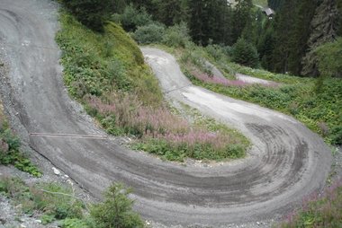
- Bieler Höhe is the pass summit of the Silvretta High Alpine Road, beside the Silvretta reservoir, with big views.
- Dreiländerspitze is a high peak where Tyrol, Vorarlberg and Switzerland meet.
- Vallülasee is a mountain lake in the Silvretta.
- Fluchthorn is a high peak above the valley.
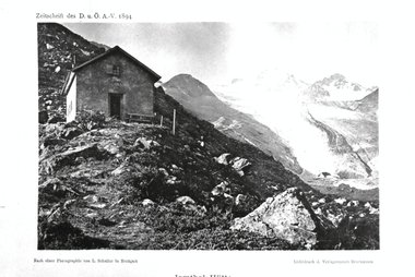
- Jamtalhütte is a mountain hut in the Jamtal, a long glacier valley.
- Zeinisjoch is a pass with views over the valley.
- Erlebnishallenbad Silvapark is an indoor pool in the village.
- The Alpinarium is a museum about life in the high mountains and the 1999 avalanche, which hit the village.
Opplevelser verdt å få med seg
- Drive the Silvretta High Alpine Road in summer.
- Hike to a mountain hut.
- Ski the high slopes.
- Try ski touring or cross-country skiing.
- Visit the Alpinarium.
Turer og aktiviteter
Galtür – Kart

Dagsturer
Steder å utforske
Reise dit
- By air: Innsbruck Airport is about 2 hours away by car. Zurich is about 3 hours.
- By train: Take a train to Landeck-Zams on the Arlberg line, then a bus up the Paznaun valley. The bus takes about 1 hour. Check train times on ÖBB.
- By car: Leave the A12 motorway at Landeck and follow the Paznaun road.
Komme seg rundt
The village centre is walkable. A local bus runs the length of the valley, and ski buses link the lifts. Hikers use buses for trailheads.
Kjøring
A car is helpful for the Silvretta road, which is a toll road and runs only in summer. The Paznaun road has hairpins and can close in heavy snow. Winter tyres or chains are required. Motorways in Austria need a vignette.
Mat og drikke
Tyrolean food is hearty. Try Tiroler Gröstl, a pan of potatoes and meat, and Kaspressknödel, cheese dumplings in broth. Mountain huts serve soups and cakes.
Sikkerhet og helse
Galtür is very safe, but avalanche risk is real in winter. Check bulletins and stay on marked slopes. High mountain weather changes fast. Tap water is clean and safe to drink. The emergency number is 112. The mountain rescue number is 140.
Historie
Galtür was settled by Walser people from the Valais in the Middle Ages, and the old village still shows their influence. The Silvretta road opened in the 1950s and linked the valley with Vorarlberg. In February 1999 a huge avalanche killed 31 people, and the village built a protective wall and the Alpinarium afterward.
Fakta om landet
Quick practical facts for Austria at a glance:
- Valuta
- euro EUR € · Kortbetaling · Vanligvis akseptert
- Nødnumre
- 112
- Elektrisitet
- 230 V · 50 HzType C / Type F
- Språk
- tysk
- Kranvann
- Trygt å drikke
- Kjøreside
- Høyre
- Retningsnummer
- +43


Galtür – Legg til i reisen din
Lag en detaljert reiseplan med smart ruteberegning, tidsestimater og alt du trenger for en perfekt reise.


Lignende destinasjoner

Data: © OpenStreetMap contributors, Wikidata, Wikipedia, Tripomatic, Official websites, geoBoundaries (CC BY 4.0). Tours by GetYourGuide. We earn commission from bookings. Travel guide generated with AI.
Planlegg reisen din med Tripomatic
- AI-drevet planleggingLa AI bygge reiseplanen din, svare på reisespørsmål og legge inn bestillingsdokumentene dine i reisen.
- ReisevarslerOffisielle reiseråd, ekstremvær, streiker og naturfarer for stedene på hver dag av reisen din.
- Helligdager og arrangementerSe høytidsdager, festivaler og stengte dager under reisen din, og hva de betyr for planene dine.
- KostnadsberegningAI-drevne kostnadsoverslag for reisen, slik at du har oversikt over budsjettet før du drar.
- Turer og billetterBestill turer, forbi-køen-billetter og aktiviteter direkte i reiseplanen din.