


Alta
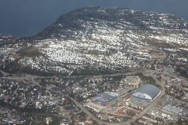
Alta is the largest town in Finnmark, Norway's far north-eastern county. It sits where the Alta river meets the Altafjord, about 70 degrees north. The town itself is modern and practical, rebuilt after the Second World War, but its setting is the reason to come. Thousands of prehistoric rock carvings lie on the shore just west of the centre, and they form a UNESCO World Heritage Site.
Alta calls itself the "Northern Lights City", and winter is its main season. Alta gets relatively little rain and snow for northern Norway, which helps the odds of clear skies for the aurora. You can add husky sledding, an ice hotel and the Finnmark plateau. In summer the midnight sun, salmon fishing on the Alta river and hikes to Northern Europe's largest canyon take over. Alta is also a meeting place of Sámi, Kven and Norwegian cultures, and a good base for exploring the rest of Finnmark.

Alta – planujesz wycieczkę?
Stwórz swój plan podróży dzień po dniu w aplikacji Tripomatic.


Kiedy jechać
Winter is long, cold and dark, with snow from October to May. It is also the main season: from late autumn to March the long nights give the best chance of seeing the northern lights. Around midwinter the sun does not rise at all, but there are a few hours of blue twilight at midday. Summer is short and mild, with the midnight sun from about mid-May to late July. The outdoor rock art area is open only when it is free of snow, usually from May until the first snow in October or November.
The biggest event is Finnmarksløpet in March, Europe's longest sled-dog race. Teams start in central Alta and race up to about 1,200 km across Finnmark, and the town is busy for the start weekend.
Główne zabytki
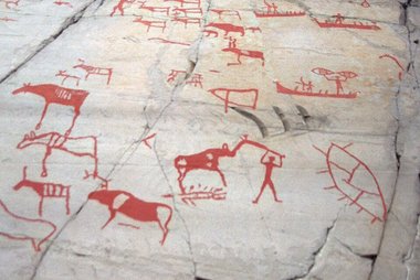
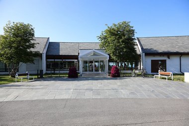

The Rock Art of Alta is the reason most people come to Alta. More than 6,000 carvings of reindeer, elk, bears, boats and people have been found around Alta, made by hunter-gatherers over several thousand years. At Hjemmeluft, about 5 km west of the centre, wooden paths of 1.2 km or about 3 km lead across the rocks. The outdoor area is open roughly from May to October; in winter the carvings lie under snow. Alta Museum World Heritage Rock Art Centre on the site is open all year and explains the carvings and the region's history.
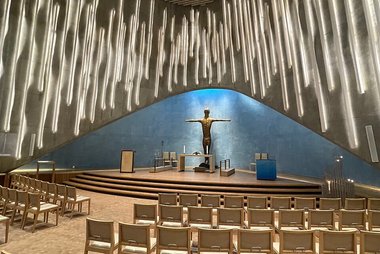
Northern Lights Cathedral stands in the town centre. Its titanium-clad spiral tower was designed by Schmidt Hammer Lassen Architects and opened in 2013. Inside, the calm concrete-and-wood interior holds artwork by Peter Brandes.
Tirpitz Museum lies in Kåfjord, about 20 minutes' drive west of town. The German battleship Tirpitz was anchored in this fjord during the Second World War, and the museum shows photos, models and objects from the ship and the occupation. It is mainly open in summer.
Sautso Canyon, also called the Alta Canyon, is Northern Europe's largest canyon, more than 400 m deep. It starts below the Alta power station, south of town. Reaching the viewpoint means a long hike across the plateau, about 13 km from Bæskades on the road to Kautokeino, or a guided tour.
For an easy view over the town and the fjord, walk up Komsa, the small mountain by Bossekop at the head of the fjord. The trail starts near Komsa school, and the top is a popular spot to watch the midnight sun.
Czego warto doświadczyć
Many of Alta's best moments happen outdoors and depend on the season.
- Chase the northern lights: from autumn to March, join a guided aurora trip or drive away from the town lights on a clear night. Clear, cold nights are best.
- Husky sledding: Alta is a sled-dog town. Local kennels offer short rides and longer trips across the snow, and in March you can watch the Finnmarksløpet teams leave the town centre.
- Visit the ice hotel: the Sorrisniva Igloo Hotel, about 20 km from town on the Alta river, is built new from ice and snow every winter and is open from late December to the beginning of April. It has an ice chapel and a new artistic theme each year.
- River boat into the canyon: in summer, when the water is high enough, traditional long river boats take visitors up the Alta river from Sorrisniva towards the canyon.
- Salmon fishing: the Alta river is one of Norway's most famous salmon rivers, known for very large fish. Fishing needs a licence and is strictly regulated, so arrange it in advance.
- Midnight sun walk: from mid-May to late July, climb Komsa or the hill above the rock art area to see the sun stay above the horizon at midnight.
Wycieczki i aktywności
Alta — Mapa

Wycieczki jednodniowe
Distances in Finnmark are long, so most day trips mean an early start. Check timetables in advance, because buses and boats run only a few times a day.
- Hammerfest: under 2 hours by fast passenger boat or about 2.5 hours by bus. The boat ride along the fjords is a sight in itself, and the harbour town is one of the northernmost in the world.
- Kautokeino: under 3 hours by bus along the E45, across the Finnmark plateau. It is a centre of Sámi culture and home to the Sámi University College.
- Honningsvåg and the North Cape: about 3.5 hours by bus to Honningsvåg, with a change in Olderfjord. The North Cape cliff is the classic "top of Europe" stop; this is a very long day, and the last stretch of road can close in winter storms.
Gdzie warto się udać
Alta belongs to Northern Norway.
- Heading south-west: Tromsø is the region's largest city and the main flight hub, a short flight or a long, scenic drive away.
- Heading east: Kirkenes lies near the Russian border at the far end of Finnmark, best reached by plane.
- Heading south: Narvik and the Lofoten villages Henningsvær and Reine are much farther down the coast, good for a longer northern Norway trip.
Jak dotrzeć
- By air: Alta Airport (ALF) is about 5 km east of the centre. There are direct flights from Oslo and Tromsø, and small regional planes to other towns in Finnmark. A local bus runs to the centre in about 10 minutes, and taxis wait at the terminal. Alta Airport (Avinor)
- By train: there is no railway in Finnmark.
- By bus: regional buses run to Hammerfest, Kautokeino, Honningsvåg and Tromsø. The Tromsø route is a long ride on the E6 along the Lyngenfjord. Snelandia (Finnmark public transport)
- By boat: a fast passenger boat links Alta with Hammerfest in under 2 hours. It does not carry cars.
- By car: the E6 runs through Alta, and the E45 from Finland and Kautokeino ends here.
Poruszanie się na miejscu
- Local buses: Snelandia runs the town buses, including a route to the airport. The cheapest ticket is in the Snelandia Mobillett app; you can also buy a ticket on board. Snelandia
- Taxi: taxis are available but expensive; book ahead for early flights or late returns from aurora trips.
- Car: the main sights are spread out, from the rock art west of town to the canyon in the south. A car or a guided tour makes most of them easier.
- On foot: the centre is compact and easy to walk, but pavements are often icy in winter. Wear shoes with good grip or slip-on spikes.
- Cycling: practical in summer on mostly flat roads; not realistic in winter.
Prowadzenie samochodu
- Is a car worth it? Yes, if you want to explore. Sights are spread out and public transport is thin, so a car gives you much more freedom. In winter only drive if you are used to snow and ice; otherwise use guided tours.
- Winter roads: conditions change fast, so make sure your car has winter tyres. In storms, some mountain roads in Finnmark close or allow traffic only in convoy behind a snowplough. Check road status before long drives. Norwegian Public Roads Administration traffic information
- Wildlife: reindeer often stand on or beside the road, especially on the plateau. Slow down when you see them.
- Aurora watching: never stop on the road itself to look at the sky. Use a proper parking area or lay-by.
- Parking: easy to find in the centre and at the main sights.
Jedzenie i napoje
Food in Alta reflects the Arctic and the Sámi kitchen. Look for reindeer, often served as a stew or thin-sliced, Arctic char and salmon, and cloudberries for dessert in late summer. Many winter activity trips include a meal in a lavvo, a traditional Sámi tent, with a fire in the middle.
Most restaurants and cafés are in the compact centre around the Northern Lights Cathedral and the shopping streets nearby. Hotel restaurants are an important part of the dining scene. Prices are high, as everywhere in Norway, and smaller places may close early in the evening.
Bezpieczeństwo i zdrowie
Alta is very safe, and crime against visitors is rare. The real risks come from the climate.
- Cold: winter temperatures often fall well below freezing, and wind makes it feel colder. Dress in layers, with a warm hat, gloves and boots. Tour operators often lend thermal suits.
- Ice and darkness: icy pavements cause most injuries. Use shoes with spikes in winter, and carry a reflector or light when walking along roads in the dark.
- Weather: storms can cancel flights, buses and boats. Leave a buffer before an onward flight.
- Outdoors: on the plateau, phone coverage can be poor and help is far away. Tell someone your plans, and follow local advice on hikes. In summer, bring insect repellent for the mosquitoes.
Historia
People have lived around Alta since the end of the last Ice Age. The early Stone Age culture of Finnmark is named after Komsa, the mountain above town. The hunter-gatherers who lived here left the carvings at The Rock Art of Alta, found in 1973 and listed by UNESCO in 1985. Because the land has slowly risen since the Ice Age, the oldest carvings now lie highest above the sea.
During the Second World War the Altafjord was a major German naval base. The battleship Tirpitz lay in Kåfjord, as shown at Tirpitz Museum. When German forces retreated in 1944, they burned most of the town, so almost all of today's Alta was built after the war.
From the 1970s, plans to dam the Alta river led to the Alta conflict, one of Norway's biggest protest movements. Environmentalists and Sámi activists camped at the building site, and Sámi protesters held a hunger strike outside the Norwegian parliament in Oslo. The power station was finished in 1987 just above Sautso Canyon, but the conflict put Sámi rights firmly on the national agenda. Alta was granted town status in 2000, joining the settlements of Bossekop, Elvebakken and Bukta into one town; Northern Lights Cathedral followed in 2013 as its new main church.
Informacje o kraju
Quick practical facts for Norway at a glance:
- Waluta
- korona norweska NOK kr · Płatności kartą · Powszechnie akceptowane
- Elektryczność
- 230 V · 50 HzTyp C / Typ F
- Języki
- norweski (bokmål), norweski (nynorsk)
- Woda z kranu
- Zdatna do picia
- Ruch drogowy
- Prawostronny
- Numer kierunkowy
- +47


Alta – dodaj do wycieczki
Stwórz szczegółowy plan podróży z inteligentnym wyznaczaniem tras, szacowanym czasem i wszystkim, czego potrzebujesz do udanej wycieczki.


Powiązane cele podróży


Data: © OpenStreetMap contributors, Wikidata, Wikipedia, Tripomatic, Official websites. Tours by GetYourGuide. We earn commission from bookings. Travel guide generated with AI.