


La Palma
La Palma is a steep volcanic island with pine forest, laurel forest and deep ravines. It is known as "La Isla Bonita" and is a UNESCO Biosphere Reserve.
The trip here is about walking and the night sky. Trails cross craters and forest, and the island has an astronomical observatory and a protected-sky law. The 2021 Tajogaite eruption is part of the story today, and visitors can see its lava fields. The island suits hikers, stargazers and travellers who like quiet towns more than big resorts.

La Palma – planujesz wycieczkę?
Stwórz swój plan podróży dzień po dniu w aplikacji Tripomatic.


Kiedy jechać
The island is mild all year. The north and the high mountains are cloudier and wetter. The south and southwest are drier and sunnier. Winter brings the most rain, and summer is the driest season. Skies are often clear above the clouds, which is why the observatory is up there.
The biggest event is Los Indianos, on Carnival Monday in Santa Cruz de La Palma (February or March). Crowds in white clothes throw talcum powder in the streets, and the town fills up. Book rooms and rental cars well ahead if you plan to come.
Najlepszy czas na wizytę: styczeń, luty, marzec, kwiecień, maj, czerwiec, lipiec, sierpień, wrzesień, październik, listopad, grudzień
Główne zabytki
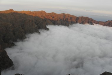



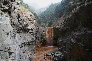


- Parque Nacional de la Caldera de Taburiente is the island's national park. It is a huge volcanic crater in the north, and the main hiking area on the island.
- Roque de los Muchachos is the island's highest point at 2,426 m. Telescopes of the Roque de los Muchachos Observatory stand near the summit, and the road to it is a popular drive.
- Volcán de Tajogaite is the cone of the 2021 eruption. The eruption lasted 85 days. The walk to the cone is possible only with authorised tour companies.
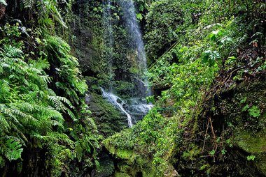
- Los Tilos is a laurel forest in the northeast, with ferns and streams. It is a cool, green contrast to the dry south.
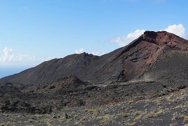
- Volcán de Teneguía is the volcano that erupted in 1971. It is at the southern end of the Cumbre Vieja ridge.
- Salinas de Fuencaliente are salt ponds beside the lighthouse at the island's southern tip.
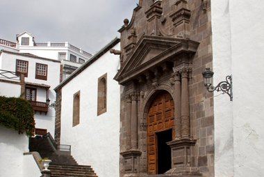
- Iglesia de El Salvador is the main church of Santa Cruz de La Palma. It stands on Plaza de España, which has fine Renaissance buildings.
- Museo Naval (Barco) is a museum in a ship-shaped building in Santa Cruz.
- Balcones típicos are the wooden balconies along the seafront in Santa Cruz. They are the town's best-known image.
Polecane zestawienia


Czego warto doświadczyć
Things to do and attend on La Palma:
- Stargazing: The island is certified as a Starlight Destination and Reserve and has its own law against light pollution. Viewpoints for the night sky include Mirador del Molino in Barlovento, Montaña Las Toscas in Villa de Mazo, and Mirador Monumento al Infinito in San Andrés y Sauces. The Geminid meteor shower in mid-December is on the island's events calendar.
- Observatory visit: The observatory at Roque de los Muchachos is a working science site. Guided visits to the telescopes must be booked ahead and run in the morning. There are no night visits. For stargazing, book a separate astronomy tour. It is above 2,000 m, cold and thin-aired, so bring warm clothes.
- Hike the Ruta de los Volcanes: This 18 km walk runs along the Cumbre Vieja ridge from Refugio del Pilar to Fuencaliente. The high section has views to Tenerife, La Gomera and El Hierro on clear days.
- Hike inside the Caldera: Walk down the Los Brecitos track into Parque Nacional de la Caldera de Taburiente and camp at the one permitted campsite. Camping permits are free. Request one well ahead at reservasparquesnacionales.es.
- Los Indianos carnival: On Carnival Monday, people in white suits and hats throw talcum powder in Santa Cruz de La Palma, with Cuban music.
- Bajada de la Virgen: Every five years in July, Santa Cruz holds a large festival for the Virgen de las Nieves, with the Dance of the Dwarfs. The next one is in 2030.
- Corpus Christi carpets: In Villa de Mazo, residents make carpets of flowers and moss for the Corpus Christi festival.
Wycieczki i aktywności
La Palma — Mapa

 Otwórz interaktywną mapę
Gdzie warto się udać
- Start in Santa Cruz de La Palma, the island's capital and main port.
- Other Canary Islands: Tenerife and Gran Canaria have the ferry and flight links to La Palma. La Gomera and El Hierro are the nearby smaller islands.
Jak dotrzeć
- By air: La Palma Airport is on the east coast, just south of Santa Cruz de La Palma. Binter and CanaryFly fly from Tenerife and Gran Canaria (30 to 45 minutes). Iberia flies direct from Madrid and Vueling from Barcelona. Direct flights from Germany, the UK, Switzerland, the Netherlands and other countries run in season.
- Airport transfer: Taxis wait at the airport. Ask for the fare before you start, especially for the west side.
- By ferry: Fred. Olsen Express sails from Los Cristianos on Tenerife to Santa Cruz de La Palma in about 2.5 hours. Baleària also sails this route. From Gran Canaria the ferry goes via Tenerife, so flying is faster. Fred. Olsen Express
- Strong west winds can delay or cancel flights at La Palma Airport. Leave a buffer on the day you fly home.
Poruszanie się na miejscu
- Car: A rental car is the easiest way to see the island. See the driving section.
- Bus: An island bus network links the towns. Services are less frequent than in a city, so check timetables for the day.
- Taxi: Taxis are useful for the airport and for trail starts.
- Roque de los Muchachos: There is no regular bus to the summit. Go by car, taxi or organised tour.
- Caldera de Taburiente: A 4x4 taxi from the Barranco de las Angustias car park takes hikers to Los Brecitos. It runs in the morning only (about 8:30 to 13:30 in summer, 9:00 to 12:00 in winter).
- On foot: The old centre of Santa Cruz is small and easy to walk. Outside towns, roads are steep and narrow.
Prowadzenie samochodu
- Is a car worth it? Yes. Trailheads, viewpoints and villages are spread over the island.
- Drive times (approximate, in good conditions): Santa Cruz to Los Llanos de Aridane 40 minutes; Santa Cruz to Fuencaliente 45 minutes; Los Llanos to the Cumbrecita viewpoint 25 minutes; Los Llanos to Roque de los Muchachos about 1 hour 20 minutes.
- Mountain weather: The observatory is above 2,000 m. Check the forecast before you drive up.
- Caldera de Taburiente: The road to the Cumbrecita viewpoint is open 8:30 to 16:00 and needs a free reservation at reservasparquesnacionales.es. Parking is not allowed on the Los Brecitos track. Most hikers take a taxi from the Barranco de las Angustias car park.
Jedzenie i napoje
Food here is Canarian. A basic dish to try is small wrinkled potatoes with mojo sauce. Cheese from La Palma has a protected designation of origin. The island also has its own wine designation, and vineyards grow around Fuencaliente in the south.
Bezpieczeństwo i zdrowie
- Mountains: Weather changes quickly above the clouds. At the observatory and the high trails, take warm clothes, water and a charged phone. Check trail conditions at the park information booths in the Caldera area.
- Volcano areas: The Tajogaite cone can only be visited with authorised companies. Volcanic gas is still monitored in Puerto Naos and La Bombilla, and access to some buildings is limited. Check local information before you go.
- Emergency: Call 112.
Historia
Santa Cruz de La Palma was founded in 1493 by Alonso Fernández de Lugo. Its sheltered bay made it a major port, as the last stop on the route to the Americas. The island has a long history of emigration to Latin America. The Los Indianos carnival parodies the return of those emigrants.
The best of this history is in Santa Cruz. Iglesia de El Salvador is documented from 1512, and Castillo de Santa Catalina is one of the few old fortifications that remain.
Volcanoes shaped the island more recently. The Cumbre Vieja ridge is about 25 km long, and eruptions have happened along its whole length. The San Juan volcano erupted in 1949 and Volcán de Teneguía in 1971.
The 2021 eruption began on 19 September near Las Manchas, in the municipality of El Paso. It lasted 85 days, until 13 December, and is the longest recorded on the island. About 7,000 people were evacuated, and lava covered more than 1,000 hectares. The new volcano was named Tajogaite. See Volcán de Tajogaite.
Informacje o kraju
Quick practical facts for Spain at a glance:
- Waluta
- euro EUR € · Płatności kartą · Powszechnie akceptowane
- Numery alarmowe
- 112
- Elektryczność
- 230 V · 50 HzTyp C / Typ F
- Języki
- hiszpański
- Woda z kranu
- Zdatna do picia
- Ruch drogowy
- Prawostronny
- Numer kierunkowy
- +34


La Palma – zaplanuj swoje dni
Zmień miejsca z tego przewodnika w prawdziwy plan podróży z inteligentnym wyznaczaniem tras, szacowanym czasem i wszystkim, czego potrzebujesz na udaną wycieczkę.


Powiązane cele podróży


Data: © OpenStreetMap contributors, Wikidata, Wikipedia, Tripomatic, Official websites. Tours by GetYourGuide. We earn commission from bookings. Travel guide generated with AI.