


Jeju
Jeju Island is South Korea's largest island, a volcanic landmass rising from the sea about 80 km south of the mainland. It was built by a huge shield volcano, and its black lava coastline, cone-shaped hills, and the mountain at its center still show that history everywhere you look. The island holds a rare "triple crown" from UNESCO: it is a Biosphere Reserve, a World Natural Heritage Site, and a Global Geopark, all for its volcanic landscape.
The pace here is slower than Seoul. Visitors come for hiking, beaches, waterfalls, and open-air scenery rather than nightlife or shopping. Jeju also has its own culture within Korea, including a distinct dialect and the famous haenyeo women divers, so it feels like a self-contained world rather than a side trip. A few days are enough to see the highlights; a week lets you circle the coast and slow down.

Jeju – A planear uma viagem?
Cria o teu itinerário dia a dia na app Tripomatic.


Quando visitar
Spring and autumn are the best times to visit. Spring brings canola flowers and mild, comfortable weather; autumn is dry and clear, with good visibility for hiking Hallasan. Summer is hot and humid, with a monsoon season and the occasional typhoon, though beaches are at their best. Winter is mild for Korea but can be windy and wet, and snow sometimes closes the upper trails on Hallasan.
Plan around the citrus harvest in late autumn to early winter, when tangerine orchards across the island open for picking, and around the camellia bloom from late autumn through winter at gardens such as Camellia Hill.
Melhor altura para visitar: junho, setembro, outubro
Principais atrações
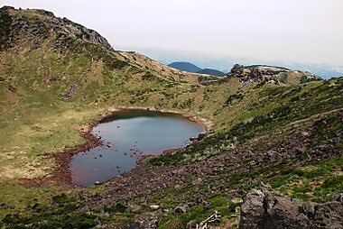





Hallasan is South Korea's highest peak, a dormant shield volcano with a crater lake at its summit. Several marked trails climb it, ranging from an easy forest walk to a full-day hike to the crater rim.
Seongsan Ilchulbong is a tuff cone that rises straight out of the sea on the island's east coast. Climbing to its grassy crater rim for sunrise is one of the island's signature experiences, and the peak is part of Jeju's UNESCO World Natural Heritage listing.
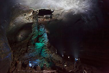
Manjanggul Cave is a lava tube stretching for kilometers underground, with about a kilometer open to walk through. Inside are towering lava columns and rippled floors left by the flowing magma, best seen with a jacket for the cool, damp air.
Daepo Jusangjeolli Cliff is a stretch of coast where cooling lava cracked into tall hexagonal stone columns. Waves crash against them dramatically when the sea is rough, and calmer days are better for a closer look.
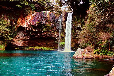
Cheonjiyeon Waterfall drops in a single sheer curtain straight into a pool near the sea, one of the few waterfalls in Asia that flows directly into the ocean. A short forest path leads from the entrance to the base.
Oedolgae Rock is a solitary rock pillar rising from the water near Seogwipo, reached by an easy coastal walking trail with sea views the whole way.
Seongeup Folk Village is a centuries-old walled village where people still live in traditional homes with thatched roofs and low stone walls. It gives a sense of what rural Jeju life looked like before the island's tourism boom.
Listas em destaque


Jeju's Best Beaches
Jeju Island's coastline features a diverse range of beaches, from the white shell sands of Hyeopjae to the volcanic black sands of Samyang. These shores are characterized by unique geological features like the moss-covered rocks of Gwangchigi and the horse-shaped lighthouses of Iho Tewoo. Visitors can find shallow turquoise lagoons at Hamdeok and Pyoseon, or explore wind-swept surfing spots at Sinyang Seopji. Many locations also feature natural freshwater springs, known as Yongcheon-su, that emerge near the sea.
26 lugares
Jeju Museums and Art Centers
Jeju Island's museum scene spans from traditional Korean heritage to quirky modern pop culture. This collection features the Jeju Aerospace Museum's aviation history, the World Automobile Museum's classic car collection, and the Osulloc Tea Museum's focus on green tea traditions. Visitors can explore unique niche attractions like the Teddy Bear Museum, the erotic sculptures of Love Land, and the Chusajeokgeoji Memorial Hall, which honors the island's history of scholarly exile. Artistic displays at the Glass Castle and traditional dak-paper doll crafts provide insight into both local and international creativity.
20 lugares
O que experienciar
- Watch a haenyeo diving demonstration. Jeju's women free-divers harvest shellfish and seafood by holding their breath, a tradition recognized by UNESCO as Intangible Cultural Heritage. Several coastal villages hold short public demonstrations at set times, and Jeju Haenyeo Museum explains the culture behind it in depth.
- Walk a stretch of the Jeju Olle Trail. This network of coastal walking routes circles the whole island in linked sections, each numbered and color-marked, so you can join for an hour or hike a full course.
- Pick your own tangerines. Citrus orchards across the island open to visitors during the harvest, letting you pick and eat fresh Jeju tangerines straight from the tree.
- Ride the black lava coast road. Renting a scooter or bike for a stretch of the coastal road, especially around Seogwipo, gives close-up views of the volcanic rock shoreline that a car window doesn't.
Excursões e atividades
Jeju — Mapa

 Abrir o mapa interativo
Passeios de um dia
The satellite islands off Jeju's coast make easy day trips by ferry, each with its own character.
- Udo Island — ≈15 min by ferry from Seongsan, plus a short drive or bus to the ferry pier. The most popular of the small islands, known for its bright turquoise water, peanut ice cream, and a full loop road that is easy to cycle or scooter in half a day.
- Marado Island — a short ferry ride from Moseulpo, near Jeju's southern tip. South Korea's southernmost point, a small, mostly flat island you can walk around in under two hours.
- Biyangdo Island — a short ferry ride from Hallim, off the northwest coast. Quiet and less visited, with a short hike to a hilltop lighthouse and views back across the strait to Jeju.
Ferries to all three run only in good weather and are cancelled in high wind or swell, so build in a flexible day if one of these is a priority.
Onde explorar
Jeju Island has two main cities, on opposite coasts, and most trips are based in one or split between both.
- Jeju City — on the north coast, home to the airport and the island's largest urban area. A practical base for flights and for exploring the north and west.
- Seogwipo — on the south coast, closer to the waterfalls, Jusangjeolli cliffs, and Hallasan's southern trails. Quieter and greener, with a more relaxed pace than Jeju City.
Como chegar
- By air: Jeju International Airport (CJU) sits on the edge of Jeju City and is one of the busiest domestic airports in the country, with frequent flights from Seoul and other mainland cities, plus a growing number of direct international routes. The airport is close to the city center, and taxis and buses reach downtown in well under an hour.
- By ferry: Car and passenger ferries connect Jeju to the southwestern mainland, mainly from Mokpo and Wando, with crossings of roughly 2.5 to 4.5 hours depending on the route. This is a practical option if bringing a car from the mainland, but far slower than flying.
Como se deslocar
- Car rental: The easiest way to see the island. Sights are spread along the coast and around Hallasan, well beyond comfortable public-transport range, and most visitors rent a car at the airport. Foreign visitors need a physical International Driving Permit, obtained in their home country before the trip — it cannot be issued or emailed after arrival, and a digital copy is not accepted.
- Public buses: A network of intercity and local buses covers the whole island, including express routes around the coastal ring road. Fares are paid with a rechargeable T-money card or cash on board; T-money cards are sold at convenience stores.
- Taxi: Widely available in both cities and metered; useful for shorter hops if you are not renting a car.
- On foot / cycling: Both cities are walkable in their centers, and the coastal roads are popular for cycling, but the island as a whole is too spread out to explore without a car or bus.
Conduzir
- Is a car worth it? Yes — Jeju's sights are spread around a large island with limited rail (there is none) and buses that run less often outside the two cities. A rental car is the standard way to see the coast and the interior in one trip.
- Parking: Free parking lots are common at major sights and beaches; both cities have paid public parking near their centers, generally paid by the hour at a machine or booth.
- Roads: The coastal ring road (Route 1132) and the cross-island routes past Hallasan are well maintained. Winter weather occasionally closes the higher mountain roads, so check conditions before driving up in that season.
Comida e bebida
Jeju's food is shaped by the sea and the island's volcanic soil. Black pork (heukdwaeji), a native pig breed grilled tableside, is the island's signature dish, and fresh raw fish (hoe) straight from the day's catch is common at coastal restaurants. Look for it in the grilled-pork restaurant strip in central Jeju City, known locally as Black Pork Street.
Jeju is also Korea's main citrus-growing region, so tangerines and the mandarin-orange hybrid hallabong show up everywhere, from street stalls to desserts. For tea and citrus-flavored sweets in one stop, O'sulloc Tea Museum combines a working green-tea plantation with a museum and café.
Segurança e saúde
Jeju is very safe for tourists, with low rates of violent crime. The main risks are outdoors: sudden weather changes on Hallasan, strong currents at some beaches, and slippery volcanic rock along the coast, so follow posted warnings and trail closure times. Tap water is safe to drink island-wide. Typhoons can affect the island in late summer and early autumn, sometimes disrupting flights and ferries — check forecasts if traveling in that window.
História
Jeju's founding legend says three demigods rose from the ground at a site in modern Jeju City and became the ancestors of the island's first people, founders of the ancient Tamna kingdom. Tamna traded and ruled itself independently for centuries before coming under Korean control.
In the 13th century, Mongol forces occupying the island under the Yuan dynasty turned part of it into a horse-breeding ground. That is why Jeju still has its own small, sturdy native horse breed today. The island's black basalt "grandfather" statues, dol hareubang, are carved from the same volcanic rock as the landscape. They were placed as guardian figures at village and gate entrances, and are now Jeju's best-known folk symbol.
The 20th century brought tragedy: in 1948–49, an uprising and the government's brutal suppression of it killed tens of thousands of islanders, a period known as the April 3 Incident. It remained a taboo subject for decades and is now formally recognized, with a peace memorial dedicated to the victims.
Factos sobre o país
Quick practical facts for South Korea at a glance:
- Moeda
- Won sul-coreano KRW ₩ · Pagamentos com cartão · Amplamente aceite
- Eletricidade
- 220 V · 60 HzTipo C / Tipo F
- Idiomas
- coreano
- Água da torneira
- Própria para beber
- Sentido de condução
- Direita
- Indicativo telefónico
- +82


Jeju – Planeia os teus dias
Transforma os lugares deste guia num verdadeiro itinerário, com rotas inteligentes, estimativas de tempo e tudo o que precisas para uma viagem perfeita.

