



Cusco Department
The Cusco department covers the old heartland of the Inca empire. It runs from high puna in the south to cloud forest in the north, on the edge of the Amazon. Most of what draws visitors sits in a band around the regional capital. That band holds the Sacred Valley, a dense group of Inca sites, and Machu Picchu at the end of the rail line.
Most visitors base themselves in Cusco city and travel out each day. Staying a night or two down in the valley makes the region easier to cover. Altitudes range from roughly 2,000 m on the valley floor to passes above 4,800 m. Plan for the height as much as the distance. Two weeks lets you add a trek or the remoter ruins; one week covers the main circuit.

Cusco Department – Planning a Trip?
Build your day-by-day itinerary in the Tripomatic app.


When to visit
May to September is the dry season and the practical window for trekking and for the high passes. Expect bright days, hard frost at night above 4,000 m, and busy sites in July and August. From November to April it rains most afternoons, roads to remote sites wash out, and the Inca Trail closes for all of February.
The date to plan around is Inti Raymi on 24 June in Cusco city, the largest festival in the Andes. The same month brings the Q'eswachaka bridge renewal in the south of the region. Four communities reweave a grass suspension bridge over the Apurímac gorge in three days.
Top sights
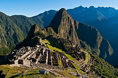


Machu Picchu is the reason most people come. The 15th-century citadel sits on a ridge above the Urubamba gorge. Entry is by timed ticket on a fixed route, so book well ahead.
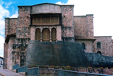
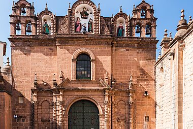
Qurikancha in the regional capital was the empire's central temple, later built over by a Spanish convent. It is the clearest single illustration of what happened to Inca Cusco.
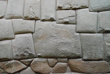
Sacsayhuamán overlooks the capital from a ridge, its zigzag walls made of blocks weighing more than 100 tonnes.
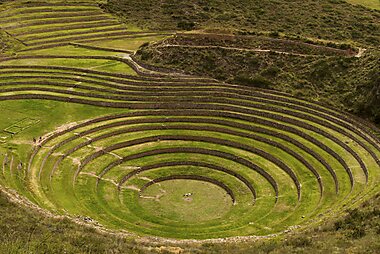
Moray is a set of deep circular terraces cut into a plateau near Maras. The temperature drops noticeably from the top ring to the bottom, and the site is widely read as an agricultural experiment.
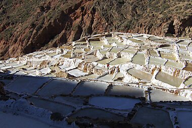
Salinas of Maras are thousands of small salt pans stepped down a ravine. They have been worked by local families since before the Spanish arrived, and still are.
Rainbow Mountain draws long day trips south of the capital for its banded mineral colours. The walk tops out above 5,000 m and is genuinely demanding.
Tipón is a terraced site southeast of the capital built around a working Inca water system, with channels and fountains still running.
Choquequirao is a large Inca complex reached only by a two-day walk in and out. It sees a tiny fraction of Machu Picchu's visitors.
Featured Lists


What to experience
Things the region is actually known for doing, spread across the year.
- Walk the Inca Trail or the Salkantay route to Machu Picchu. The classic trail is permit-controlled and sells out months ahead; Salkantay needs no permit.
- Watch the Q'eswachaka rope bridge being rebuilt each June. Local communities cut, twist and re-lay a grass suspension bridge across the Apurímac gorge in three days.
- Go to the Virgen del Carmen festival in Paucartambo in mid-July. It is three days of masked dancing, and far less staged than the events in the capital.
- Buy directly from weavers in the highland villages above the valley, where communities work with natural dyes and sell without a middleman.
- Ride the southern rail line towards Puno for the scenery, crossing the La Raya pass at over 4,300 m.
Tours & Activities
Cusco Department — Map

 Open the interactive map
 Where to explore
The region's destinations sit mostly along one corridor northwest of the capital.
- City of Cuzco is the historic core of the regional capital and the base almost everyone uses.
- Sacred Valley is the string of towns and ruins along the Urubamba river, lower and warmer than the capital.
- Pisac sits at the valley's southern end, known for its craft market and the terraced ruins above it.
- Urubamba is the valley's market town and a convenient midpoint.
- Ollantaytambo keeps its Inca street plan and is the railhead for the train onward.
- Machupicchu Historical Sanctuary is the protected area around the citadel, covering cloud forest and several other Inca sites.
Getting there
- By air: Alejandro Velasco Astete International Airport in the regional capital is the only airport with scheduled passenger service. Nearly everyone connects through Lima; the flight takes about 1 h 20 min.
- By train: There is no rail link to the coast. Rail in the region runs from Poroy and Ollantaytambo to Machu Picchu, and on a separate scenic line south to Puno.
- By bus: Long-distance coaches reach the capital from Lima in 21 to 24 h, Arequipa in about 10 h and Puno in about 7 h. Puno is the usual overland link from Lake Titicaca and Bolivia.
Official country tourism information is at PROMPERÚ.
Getting around
- Colectivos and minibuses: Shared vans link the capital with the valley towns constantly through the day. Pay the fare in cash on board. They are the cheapest way to move between towns and need no booking.
- Train: The usual way to reach Machu Picchu is the train to Aguas Calientes, then a shuttle bus up to the entrance. Book seats well ahead in high season. The budget alternative is a bus to Hidroeléctrica followed by a flat two to three hour walk along the railway.
- Organised transport: Many outlying sites, such as the salt pans and the southern colour mountains, are far easier on a day tour than by public transport.
- Car: Useful for reaching sites on your own schedule, though see the driving notes below.
Driving
- Is a car worth it?: Reasonable for the valley and the sites around the capital, where it saves waiting for colectivos. Not worth it for Machu Picchu, which no road reaches.
- Conditions: Main valley roads are paved and in fair shape. Routes to remote sites are narrow, unpaved and steep, with weather closures in the wet season. Distances take far longer than a map suggests.
- Restrictions: The historic centre of the capital has streets closed to private traffic, and parking there is scarce. Fuel stations are sparse outside the main corridor, so fill up before long stretches.
Food & drink
This is highland cooking, not the coastal seafood Peru is better known for. Cuy is roast guinea pig, served whole on festival days. Alpaca is lean and now common on menus. Chiriuchu is a cold assembly of many meats, eaten at Corpus Christi. Maras salt and native potato varieties turn up across the region. Chicha de jora, a fermented maize drink, is still made in valley villages.
For eating, the capital has the range and the valley towns have the atmosphere. Mercado de Pisac is worth timing a visit around for its food stalls as much as its crafts. In smaller villages, look for a picantería, the traditional lunch house, rather than anything aimed at visitors.
Safety & health
The region is generally safe, and the main risks are environmental rather than criminal. Petty theft happens in crowded markets and on night buses; keep bags close and use registered taxis after dark in the capital.
Altitude is the real concern and it varies a lot across the region. The capital sits near 3,400 m, valley towns are several hundred metres lower and easier, and trekking passes exceed 4,800 m. Acclimatise for two days before any high walk, and consider sleeping in the valley first, which is a genuinely gentler start. Mountain roads are the other hazard: night travel on unpaved routes is best avoided.
History
The region was the core of Tawantinsuyu, the empire the Inca ran from Cusco between roughly 1438 and 1533. Under Pachacuti it expanded fast. The estates and ceremonial sites built then are what visitors see today. Machu Picchu was a royal retreat, Moray an agricultural site, and Sacsayhuamán the stronghold above the capital.
Spanish control after 1533 was not immediate. A rebel Inca state held out in the Vilcabamba region to the northwest until 1572, and Choquequirao belongs to that late period of retreat.
Colonial rule reshaped the countryside around estates and textile workshops. In 1780 Túpac Amaru II led a large rebellion that began at Tinta in the south of the region. It was put down within two years, but it remains the founding reference point for Andean resistance.
Country facts
Quick practical facts for Peru at a glance:
- Currency
- Peruvian Sol PEN · Card payments · Commonly accepted
- Emergency numbers
- 911
- Electricity
- 220 V · 60 HzType A / Type B / Type C
- Languages
- Aymara, Spanish, Quechua
- Tap water
- Not safe to drink
- Driving side
- Right
- Calling code
- +51
Cusco Department – Plan Your Trip
Pick the places you want to see and Tripomatic turns them into a day-by-day route, with smart routing, time estimates, and everything you need for a perfect trip.




