


Lienz
Lienz is the main town of East Tyrol, set in a sunny valley where the Isel and Drau rivers meet. The Dolomites rise just to the south, and the Hohe Tauern mountains lie to the north.
The town is relaxed and friendly, with a pedestrian centre and a castle on its edge. It suits walkers, cyclists and skiers who like quieter places.

Lienz – Suunnitteletko matkaa?
Rakenna päiväkohtainen matkasuunnitelmasi Tripomatic-sovelluksessa.


Milloin matkustaa
June to September is best for hiking and cycling. Winter brings ski days and a calm Christmas market. Lienz is known for more sunshine than much of the Alps. Spring can be wet, and some mountain huts stay closed until June.
Päänähtävyydet


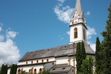
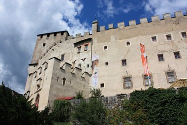
- Schloss Bruck is a medieval castle above the town with a museum of local art and history.
- Franziskanerkloster St. Marien is a monastery in the town centre.
- Herz-Jesu-Kirche is a church in the town with modern murals.
- St. Andrä is the old parish church.
- Rathaus Lienz is the town hall on the main square.
- Eisenbahnmuseum Südbahn-Heizhaus is a railway museum in an old locomotive shed.
- Hochstein is a local mountain with a cable car and walking trails.
- Venedigerwarte is a lookout tower over the valley.
- Dolomitenbad Lienz is the town's swimming pool and spa.
- The Lienz Dolomites, to the south, have jagged peaks and long hikes.
- Tristach lake, a small bathing lake, is a short drive away.
Suositellut listat

Lienz Unmissables
Lienz serves as the cultural and alpine hub of East Tyrol, centered around the 13th-century Schloss Bruck and the historic Liebburg palace. The town's architecture spans from the medieval Franciscan Friary to the 17th-century towers on the main square. Outdoor landmarks like the Hochsteinhütte at 2,023 meters and the Venedigerwarte offer extensive views of the Lienz Dolomites, while sites such as the Kosakenfriedhof provide significant historical context regarding the region's 20th-century past.
10 paikkaaMitä kokea
- Walk or cycle part of the Drau Cycle Route.
- Visit the castle and see the museum.
- Hike in the Lienz Dolomites.
- Ski at Zettersfeld or Hochstein in winter.
- Drive the Grossglockner High Alpine Road from Heiligenblut.
Kierrokset ja aktiviteetit
Lienz — Kartta

Päiväretket
- Heiligenblut, a village under the Grossglockner, is about 1 hour by car.
- The Lienz Dolomites and Lienz Dolomites cable car are about 15 minutes away.
- Tristach lake is about 10 minutes away.
- Cortina d'Ampezzo in Italy is about 1 hour 30 minutes away by car.
- Carinthia's Lake Millstatt is about 1 hour 15 minutes away.
Saapuminen
- By air: Innsbruck, Salzburg and Klagenfurt are all about 2 hours or more away.
- By train: Lienz is on the Drau Valley line. Trains from Innsbruck run via Italy or via Salzburg and take about 3 to 4 hours. Check times on ÖBB.
- By car: The B100 road follows the valley. The Felbertauern tunnel links Lienz with Mittersill and Salzburg. It is a toll road.
Liikkuminen paikan päällä
The centre is small and best on foot. Local buses link nearby villages and the Dolomites cable car. Cycling is easy on the flat valley paths. A car helps for the high roads.
Autoilu
A car is useful for the high alpine roads and the Felbertauern tunnel. Winter tyres or chains are required in snow. Motorways in Austria need a vignette. The Grossglockner road is a toll road and is closed in winter.
Ruoka ja juoma
East Tyrol cooking is simple and hearty. Try Schlipfkrapfen, pasta pockets filled with potato and herbs, and Tiroler Gröstl, a pan of potatoes and meat. Mountain huts serve warm dishes and cakes. The region is also known for dairy products.
Turvallisuus ja terveys
Lienz is very safe. Mountain trails need care: check the weather, carry water and stay on marked paths. Tap water is clean and safe to drink. The emergency number is 112. The mountain rescue number is 140.
Historia
Lienz began as a Roman settlement, Aguntum, close by. The medieval town was ruled by the Counts of Görz, whose castle is now the main museum. It passed to the Habsburgs in 1500. After World War I, East Tyrol was cut off from North Tyrol, and it is still linked to it only through Italy and by the Felbertauern road.
Tietoa maasta
Quick practical facts for Austria at a glance:
- Valuutta
- euro EUR € · Korttimaksut · Yleisesti hyväksytty
- Hätänumerot
- 112
- Sähkö
- 230 V · 50 HzTyyppi C / Tyyppi F
- Kielet
- saksa
- Hanavesi
- Juomakelpoista
- Ajosuunta
- Oikea
- Suuntanumero
- +43


Lienz – Suunnittele päiväsi
Muunna tämän oppaan paikat todelliseksi matkasuunnitelmaksi älykkäillä reiteillä, aika-arvioilla ja kaikella, mitä tarvitset onnistuneeseen matkaan.


Liittyvät määränpäät
Muut määränpäät
Data: © OpenStreetMap contributors, Wikidata, Wikipedia, Tripomatic, Official websites, geoBoundaries (CC BY 4.0). Tours by GetYourGuide. We earn commission from bookings. Travel guide generated with AI.
Suunnittele matkasi Tripomaticilla
- Tekoälypohjainen suunnitteluAnna tekoälyn rakentaa matkasuunnitelmasi, vastata matkakysymyksiin ja arkistoida varausasiakirjasi matkaasi.
- MatkustustiedotteetViralliset tiedotteet, vaaralliset säät, lakot ja luonnonkatastrofit matkasi jokaisen päivän paikkoihin.
- Juhlapyhät ja tapahtumatNäe matkasi päiville osuvat lomat, festivaalit ja sulkuajat sekä niiden vaikutus suunnitelmiisi.
- KustannusarvioTekoälypohjaiset matkakustannuserittelyt auttavat sinua hahmottamaan budjetin ennen lähtöä.
- Kierrokset ja liputVaraa kierroksia, jonon ohi -lippuja ja aktiviteetteja suoraan suunnitelmaasi.