



Kefalinia
Kefalonia is the largest island in the Ionian Sea. Steep limestone mountains, long coastlines and quiet villages make it a good choice for travelers who like scenery, swimming and slow road trips. It is spread out, so most visitors stay in two or three bases, such as Argostoli, Sami or Fiskardo, and travel by car.
Most towns were rebuilt after the 1953 earthquake, so they look modern. The main exception is Fiskardo in the north, which kept its older Venetian-style houses. Assos also keeps an old village feel. The island is also known from the novel and film Captain Corelli's Mandolin. A stay of five to seven nights lets you see the caves, the famous beaches and the north.

Kefalinia – planujesz wycieczkę?
Stwórz swój plan podróży dzień po dniu w aplikacji Tripomatic.


Kiedy jechać
May, June and September are the best months for beaches, hiking and sightseeing. July and August are the hottest and busiest months. Winter is the wettest season, and many seasonal hotels and tavernas close.
The biggest event is the feast of Saint Gerasimos, the island's patron saint. It is held on 16 August, with a second feast on 20 October. Processions and church services take place at his monastery near Omala.
Najlepszy czas na wizytę: maj, czerwiec, lipiec, sierpień, wrzesień
Główne zabytki

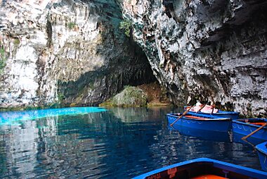


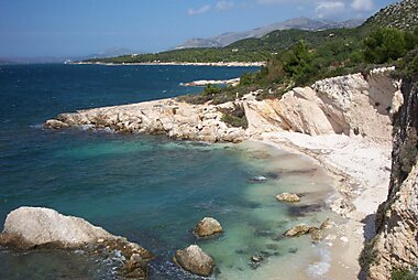


- Myrtos Beach is a long white pebble beach below steep cliffs. The sea is turquoise, and the waves can be strong, so swim with care.
- Melissani Cave is an underground lake that you visit by small boat. The cave roof has opened, so daylight reaches the water.
- Drogarati Cave is a deep cave near Sami with large rock formations. Its big chamber is known for its sound.
- Assos Fortress is a Venetian fortress on a hill above the village of Assos. A path leads up from the village, and the views over the coast are wide.
- Ainos National Park covers the island's highest mountain. It is home to the rare Cephalonian fir and is the best area for hiking.
- Antisamos Beach is a pebble beach with clear water near Sami. It is easy to combine with the caves.
- Petani Beach is a quiet beach on the Paliki peninsula, west of the Argostoli bay. Come here for a calmer day by the sea.
- Katavothres Sea Mills are the Katavothres sinkholes near Argostoli. Sea water flows into the rock here and comes out on the other side of the island.
Polecane zestawienia


Top Beaches
Cephalonia’s coastline offers a diverse range of landscapes, from the iconic white pebbles and turquoise waters of Myrtos to the unique reddish sands of the Paliki peninsula. The island features geological curiosities like the moving rock at Kounopetra and vital ecological sites such as the turtle nesting grounds at Koroni. Whether exploring the sheltered coves of Lassi or the rugged limestone cliffs of the west coast, these beaches showcase the island's distinct Mediterranean geography.
20 miejsc
Czego warto doświadczyć
- Look for loggerhead sea turtles in the harbor of Argostoli. They come close to the waterfront.
- Take the ferry across the bay from Argostoli to Lixouri for the ride and the sea views.
- Join the church celebrations for Saint Gerasimos on 16 August or 20 October.
- Go snorkeling or sea kayaking along the clear northwest coast in summer.
Wycieczki i aktywności
Kefalinia — Mapa

 Otwórz interaktywną mapę
 Wycieczki jednodniowe
The best day trips are by ferry to nearby islands. Ithaca is the easiest.
- Ithaca: A short ferry crosses from Sami, about 30 minutes each way. It runs daily in summer and rarely in winter. The island is quiet, green and has pretty harbor villages.
- Zakynthos: A seasonal summer ferry runs from the south of Kefalonia. Allow about 1.5 to 2 hours each way. Sailings are few and mostly in the morning, so check the timetable first. A full day trip is hard.
- Lefkada: A seasonal ferry links Fiskardo with Lefkada. Check the timetable before you plan the day.
Gdzie warto się udać
Jak dotrzeć
- By air: Kefalonia Island International Airport is about 10 km south of Argostoli. Many European airlines fly here in summer. Taxis and rental cars are the main ways to reach your hotel.
- By ferry from the mainland: Ferries link Sami with Patras and Poros with Kyllini. Both routes suit travelers who drive or arrive from Athens by road.
- By ferry from other islands: Sami has a link to Ithaca, and Fiskardo has links to Lefkada and Ithaca. Services change by season.
- Inside the island: A ferry crosses the Argostoli bay to Lixouri every hour in winter and more often in summer.
Poruszanie się na miejscu
- Public transport: Buses connect Argostoli with the main towns, but services are limited and few reach the beaches. Check the timetable in advance, especially outside summer.
- Taxis: Taxis are useful for short trips and airport transfers. Agree the price before you leave on long rides.
- On foot and by bike: Argostoli and Fiskardo are easy to explore on foot. The rest of the island is hilly and spread out, so cycling is hard for most visitors.
Prowadzenie samochodu
- Is a car worth it?: Yes. A car is the best way to see the island because the sights and beaches are far apart and buses are limited.
- Roads: Many roads are narrow and winding. Allow extra time for narrow mountain roads and tight bends.
- Parking: Parking at busy beaches such as Myrtos is limited and fills early in July and August. Arrive in the morning.
Jedzenie i napoje
Look for the Kefalonian meat pie and local cheeses. Robola, a dry white wine from the slopes of Mount Ainos, is the island's signature wine.
For a meal, go to the harbor front of Fiskardo or the waterfront of Assos. In Argostoli, the streets around the main square have many tavernas.
Bezpieczeństwo i zdrowie
Kefalonia is safe for visitors. Petty theft is rare, but keep valuables out of sight in parked cars.
- Sea: Some beaches, such as Myrtos, have strong waves and currents. Follow local advice before you swim.
- Summer heat and fire: Dry hills can burn in summer. Avoid open flames and follow local fire warnings.
- Earthquakes: The island is in an active earthquake zone. Serious events are rare.
- Water: Many visitors prefer bottled water for drinking, because tap water can taste of salt.
Historia
The island was ruled by Venice from 1500 to 1797. In Assos, the Venetian fortress Assos Fortress still stands above the village. The earlier capital was the Castle of Saint George, on a hill above Peratata in the south.
In 1813, during British rule, Colonel Charles Philip de Bosset built a causeway across the Argostoli lagoon. De Bosset Bridge Obelisk stands on it.
In September 1943, German forces killed thousands of Italian soldiers of the Acqui Division after they surrendered. Acqui Division Memorial remembers them.
On 12 August 1953, a strong earthquake destroyed almost every house on the island. Fiskardo was one of the few places to survive. This is why most towns were rebuilt.
Informacje o kraju
Quick practical facts for Greece at a glance:
- Waluta
- euro EUR € · Płatności kartą · Powszechnie akceptowane
- Numery alarmowe
- 112
- Elektryczność
- 230 V · 50 HzTyp C / Typ F
- Języki
- grecki
- Woda z kranu
- Zalecana ostrożność
- Ruch drogowy
- Prawostronny
- Numer kierunkowy
- +30


Kefalinia – zaplanuj swoje dni
Zmień miejsca z tego przewodnika w prawdziwy plan podróży z inteligentnym wyznaczaniem tras, szacowanym czasem i wszystkim, czego potrzebujesz na udaną wycieczkę.




