


Fuerteventura
Fuerteventura is the second-largest of the Canary Islands and the closest to Africa, about 100 km off the coast of Morocco. It is old, dry and windy, with bare brown hills, wide plains and very little green. What it does have is sand: more than 150 beaches, many of them long and white, and a large field of dunes in the north.
The island suits a relaxed beach holiday and active days in the water. Corralejo in the north and the Jandía peninsula in the south are the main bases, and both are famous for windsurfing, kitesurfing and surfing. Inland, quiet villages, windmills and the old capital Betancuria show a slower, rural side of the island. Fuerteventura is less built up than Tenerife or Gran Canaria, and in 2009 UNESCO declared the whole island a Biosphere Reserve.

Fuerteventura – Tu prépares un voyage ?
Crée ton itinéraire jour par jour dans l'application Tripomatic.


Quand partir
Fuerteventura is warm and sunny all year, and rain is rare. Winter is mild and is the busiest season for visitors from northern Europe. Summer is hot but rarely extreme, because the trade winds blow almost every day. The wind is strongest from June to August, which is the best time for windsurfing and kitesurfing but can make some beaches uncomfortable.
If you visit in November, plan around the International Kite Festival. For about a week, hundreds of colourful kites fill the sky above the beaches of Corralejo and El Cotillo. Entry is free.
Meilleure période pour visiter: janvier, février, mars, avril, mai, juin, juillet, août, septembre, octobre, novembre, décembre
Sites incontournables




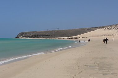
Parque Natural de Corralejo protects the largest field of sand dunes in the Canary Islands, just south of Corralejo. The main road runs right through the dunes, and long beaches line the coast on the east side.
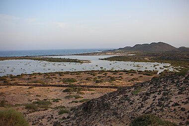
Lobos Island is a small, protected island off Corralejo, about 15 minutes away by boat. Walk to the lagoons and the clear water of the bay, or climb the low volcano for views of Lanzarote and the dunes. Visits need a permit, and the number of visitors per day is limited.
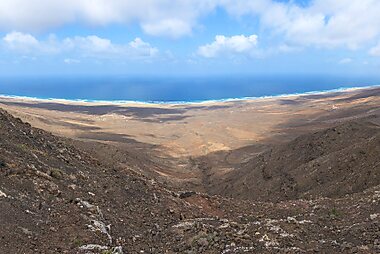
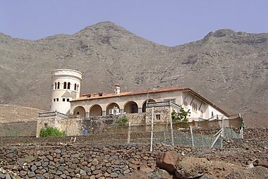
Cofete Beach is a wild beach about 12 km long on the remote west coast of the Jandía peninsula, below steep mountains. The only road there is a long gravel track over the mountains. Nearby, the lonely Villa Winter is surrounded by legends about its German owner.
Sotavento Beach is a long stretch of beach on the south-east coast of the Jandía peninsula. Around high tide, a huge shallow lagoon forms behind a sand bar, and the area is a centre for windsurfing and kitesurfing.
Cuevas de Ajuy are large sea caves in cliffs of some of the oldest rock in the Canary Islands. A short coastal path leads to them from the black sand beach of the fishing village of Ajuy.
Calderón Hondo is an extinct volcano near Lajares in the north. A marked trail climbs to a viewing platform on the rim, from where you look down into the deep crater.
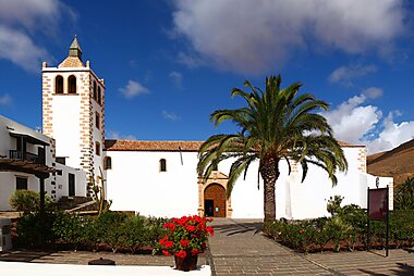
In the mountains of the centre, the old capital Betancuria sits in a green valley. Its main sight is Church of St. Mary of Betancuria, rebuilt in the 17th century after pirates burned the town. Just north, the viewpoint Morro Velosa by César Manrique looks out over the hills of the north.
The Colonel's House in La Oliva is a large 18th-century house that belonged to the island's military governors. Today it is used for art exhibitions.
Oasis Park Fuerteventura at La Lajita is the island's largest family attraction. It combines a zoo with camel rides and a big botanical garden of cactus and other dry-climate plants.
Listes recommandées


Best Beaches
Fuerteventura’s coastline ranges from the massive white sand dunes of Corralejo Natural Park to the rugged, wind-swept cliffs of the west coast. This selection highlights the island's geological diversity, including the unique rhodolith formations at Popcorn Beach, the protected lagoons of El Cotillo, and the 12-kilometer stretch of untamed shoreline at Cofete. Many locations, such as Sotavento, serve as international hubs for windsurfing and kitesurfing due to consistent trade winds and shallow tidal lagoons.
20 lieux


Cultural Heritage
Fuerteventura’s cultural heritage is defined by its traditional architecture and agricultural history. This collection features iconic "molinos" (windmills) used for grinding grain, alongside 16th and 17th-century churches like the Ermita de Nuestra Señora de Regla with its ornate facade. Explore the island's pre-Hispanic roots at the La Atalayita archaeological site or visit dedicated museums showcasing local cheese-making traditions, contemporary Canarian art, and the former home of exiled writer Miguel de Unamuno.
17 lieux
Historic Windmills
Fuerteventura’s landscape is defined by two types of traditional grain mills: the circular, multi-story 'molino' and the later, single-story 'molina'. Developed between the 18th and 19th centuries, these structures were vital for producing gofio, a staple Canary Island flour made from toasted grain. Many of these sites are now protected as cultural heritage, showcasing the island's historic reliance on trade winds for agricultural processing and food production.
11 lieux
Expériences à vivre
Fuerteventura is one of Europe's top places for windsurfing, kitesurfing and surfing.
- Learn to windsurf or kitesurf on the Sotavento lagoon. It fills for a few hours around high tide, when the water is shallow and calm. Schools along the beach teach complete beginners.
- Take a surf lesson in the north. Surf schools in Corralejo, Lajares and El Cotillo drive students to whichever beach has the right waves that day.
- Snorkel in the bay of El Puertito on Lobos Island, where the water is shallow and full of fish.
- Ride the 4x4 bus over the mountains from Morro Jable to the wild beach of Cofete.
- Watch the sunset from the old harbour of El Cotillo, next to Castle Tostón. The coast here faces west.
- Look at the night sky. Large parts of the island are a protected Starlight Reserve, and the Sicasumbre astronomical viewpoint, on the road between Pájara and La Pared, has information boards about the stars.
Visites et activités
Fuerteventura — Carte

Excursions à la journée
Two neighbouring islands are easy to reach by ferry. Check the return times before you leave.
- Lanzarote — ≈25–35 min by ferry from Corralejo to Playa Blanca. Rent a car or join a tour to see the volcanoes of Timanfaya and the art sites of César Manrique in one day.
- Gran Canaria — ≈2 h by fast ferry from Morro Jable to the port of Las Palmas. This is a long day, but enough to see the old town of Vegueta and the city beach of Las Canteras.
Où s'aventurer
On Fuerteventura
- Betancuria — the island's first capital, a small historic village in a mountain valley.
- Puerto del Rosario — the capital and main port today, with many open-air sculptures in its streets.
Nearby islands
- Lanzarote — black lava fields and the art of César Manrique, a short ferry ride north.
- La Graciosa — a tiny island with sand tracks instead of roads, off the north of Lanzarote.
- Gran Canaria — mountains, dunes and the historic city of Las Palmas.
- Tenerife — the largest Canary Island, built around the volcano Teide.
S'y rendre
- By air: Fuerteventura Airport (FUE) is about 5 km south of Puerto del Rosario. It has frequent flights from across Europe, mainland Spain and the other Canary Islands. Bus 3 goes to Puerto del Rosario and Caleta de Fuste, and bus 10 runs south to Costa Calma and Morro Jable. For Corralejo, change buses in Puerto del Rosario. Taxis wait outside the terminal. Fuerteventura Airport
- By sea: Ferries link Corralejo with Playa Blanca on Lanzarote several times a day. Ferries from Morro Jable and Puerto del Rosario go to Gran Canaria, and you can continue from there to Tenerife. A weekly ferry links Puerto del Rosario with Cádiz on mainland Spain.
Se déplacer
- Island buses: Tiadhe runs the buses (guaguas) between Puerto del Rosario, the airport, the resorts and the main villages. Pay the driver in cash and carry small notes, because bank cards are not accepted. Main routes run often, but buses to inland villages and the west coast are rare. Tiadhe
- Car: Renting a car is the easiest way to explore. Roads are good and traffic is light, but distances are longer than on Lanzarote — about 1.5 hours from Corralejo to Morro Jable.
- Taxi: Taxis are easy to find at the airport, in Puerto del Rosario and in the resorts, but expensive for long trips.
- On foot and by bike: Corralejo, Caleta de Fuste and Morro Jable are easy to walk. Cycling is popular, but the wind is strong and there is almost no shade.
Conduite
- Is a car worth it? Yes, if you want to see more than your resort. Buses are slow and do not reach most beaches, viewpoints and inland villages.
- Gravel roads: The roads to Cofete, Punta Jandía and several remote beaches are unpaved. Check whether your rental contract covers driving on unpaved roads before you go.
- Wildlife on the road: Goats often cross roads in the countryside, especially in the mountains around Betancuria.
Gastronomie
Fuerteventura's food is simple and based on goats, fish and potatoes. The island is best known for its goat's cheese, queso majorero, which has its own protected designation of origin. Try it fresh, semi-cured or cured, sometimes with a paprika or gofio crust. Goat meat stew (carne de cabra) and papas arrugadas, small potatoes boiled in salty water and served with red or green mojo sauce, are on most local menus.
For fresh fish, head to the small fishing villages: Ajuy on the west coast, El Cotillo in the north and Las Playitas in the south-east all have simple seafood restaurants by the water. Corralejo's old harbour and main street have the widest choice of restaurants and bars. To learn more about the cheese, visit the cheese museum next to the windmill in Antigua.
Sécurité et santé
Fuerteventura is a very safe island. Do not leave valuables visible in a parked car, especially at beach car parks and viewpoints.
The sea is the real danger. The west coast, including Cofete, has strong currents and big waves and no lifeguards, so do not swim there. Swim only on beaches with a lifeguard, and never when a red flag is flying.
The sun is strong all year, and the constant wind hides how fast you burn. Tap water comes from desalination plants and is safe, but most people buy bottled water for drinking because of the taste.
Histoire
The first people of Fuerteventura, the Majos, came from North Africa and lived from goats. When Europeans arrived, the island was split into two kingdoms, divided by a stone wall across the narrow isthmus of the Jandía peninsula. The Majos held the mountain of Tindaya sacred, and its rock still carries engravings in the shape of feet.
In 1402, the Norman knights Jean de Béthencourt and Gadifer de La Salle began the conquest for the Crown of Castile. Béthencourt founded Betancuria in a protected valley, and it stayed the capital for more than 400 years. Pirates raided the island often. In 1593, a Berber fleet burned the town, including its church, which was later rebuilt as Church of St. Mary of Betancuria. Small towers such as Castle Tostón were built in the 18th century to guard the coast.
In the 18th century, real power passed to the military governors, the colonels, who ruled from The Colonel's House in La Oliva. In the 19th century, the port of Puerto de Cabras grew into the capital, renamed Puerto del Rosario in 1956. In 1924, the writer Miguel de Unamuno was exiled here by the dictatorship, and he wrote many poems and articles about the island. His rooms are kept in House of Miguel de Unamuno. Tourism began in the 1960s and grew fast after the airport opened to international flights.
Infos pays
Quick practical facts for Spain at a glance:
- Devise
- euro EUR € · Paiements par carte · Largement acceptées
- Numéros d'urgence
- 112
- Électricité
- 230 V · 50 HzType C / Type F
- Langues
- espagnol
- Eau du robinet
- Potable
- Sens de conduite
- À droite
- Indicatif téléphonique
- +34


Fuerteventura – Planifie tes journées
Transforme les lieux de ce guide en un véritable itinéraire, avec des itinéraires intelligents, des estimations de temps et tout ce dont tu as besoin pour un voyage parfait.




