


Algeciras
Algeciras is a port city in the province of Cádiz, on the Bay of Algeciras, facing the Rock of Gibraltar. It has the largest port in Spain, with ferries to Tangier, Ceuta and Morocco, and it is a major crossing point between Europe and Africa.
For most visitors it is a transit stop, but it has a quiet old quarter, the Parque Natural del Estrecho nearby, and a connection to the flamenco guitarist Paco de Lucía, who was born here.

Algeciras – Reis plannen?
Stel je dagelijkse reisroute samen in de Tripomatic-app.


Beste reistijd
Spring and autumn are comfortable. Summers are hot and the levante wind can blow strongly. Winters are mild but can be rainy. In the summer, the port is very busy with the Operación Paso del Estrecho for travellers to Morocco.
Beste reistijd: april, mei, juni, juli, augustus, september, oktober
Topbezienswaardigheden



- Estatua de Paco de Lucía is a statue of Paco de Lucía, one of the great flamenco guitarists, who was born in Algeciras. The house where he was born is in the old quarter.
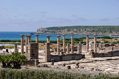
- Parque Arqueológico de las Ruinas Meriníes are the ruins of the medieval Marinid city, Al-Binya, an archaeological park in the center.
- Parque Natural del Estrecho is a nature park along the coast, with cliffs, forests and migration routes for birds crossing the Strait.
- Acueducto de El Cobre is a Roman aqueduct in the Cobre area.
- Fuerte del Tolmo is an old fort in the hills of the natural park.
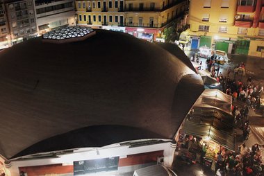
- Mercado de Abastos is the market hall in the center, and the Puerta del Mar is an old gate.
- The beaches of El Rinconcillo, Getares and El Chinarral are sandy beaches around the bay.
Aanbevolen lijsten

Wat te beleven
- Visit the Marinid ruins and the market.
- Walk in the Parque Natural del Estrecho.
- Cross the Strait to Tangier for a day.
- Visit Gibraltar and look at the Rock.
Tours en activiteiten
Algeciras — Kaart

 Interactieve kaart openen
Dagtochten
- Gibraltar (about 20 km): a British territory with a rock, a nature reserve and monkeys. Take your passport.
- Tarifa (about 20 km): the southernmost town of Spain, famous for wind sports.
- Tangier and Ceuta: ferries cross the Strait. Check entry rules.
- Ronda (about 100 km): a gorge town.
- Marbella (about 80 km): a resort town.
Plaatsen om te ontdekken
Other places nearby:
- Cádiz province: Tarifa, Cádiz and Jerez de la Frontera.
- Costa del Sol: Estepona and Marbella.
Bereikbaarheid
- By air: Gibraltar airport and Málaga airport (about 130 km) are the closest. Jerez is about 130 km.
- By train: The railway line runs to Ronda and Granada, a scenic route. Book on Renfe.
- By bus: Buses run from Málaga, Cádiz, Seville and Tarifa.
- By ferry: Ferries leave for Tangier, Tangier Med and Ceuta.
Vervoer ter plaatse
- On foot: The center and the port are walkable.
- Local bus and taxi: For the beaches and the natural park.
Autorijden
- Is a car worth it?: Useful to explore the coast and the park.
- Parking: Paid parking in the center and by the port.
- Roads: The A-7 and N-340 are busy near the port, especially in summer.
Eten en drinken
Algeciras has Andalusian food with a seafood focus. Try tortillitas de camarones, atún (tuna), pescaíto frito and rabo de toro. The Moroccan influence appears in tea and some restaurants.
Veiligheid en gezondheid
Algeciras is a port city, so keep an eye on belongings in the port area. Use official ticket offices for ferries. If you cross to Morocco, take your passport.
Geschiedenis
The Phoenicians, Carthaginians and Romans used the bay. In 711 the Moors arrived, and Algeciras was a Moorish port. In 1344 Alfonso XI of Castile took it after a siege, and in 1369 it was destroyed. It was resettled in 1704 by people from Gibraltar who left after the British took the Rock.
The port grew in the 20th century and is now one of the busiest in the Mediterranean.
Feiten over het land
Quick practical facts for Spain at a glance:
- Valuta
- Euro EUR € · Betalen met kaart · Algemeen geaccepteerd
- Noodnummers
- 112
- Elektriciteit
- 230 V · 50 HzType C / Type F
- Talen
- Spaans
- Kraanwater
- Veilig om te drinken
- Rijrichting
- Rechts
- Landnummer
- +34


Algeciras – Plan je dagen
Zet de plaatsen uit deze gids om in een echte reisroute, met slimme routes, tijdsinschattingen en alles wat je nodig hebt voor een perfecte reis.


Gerelateerde bestemmingen


Data: © OpenStreetMap contributors, Wikidata, Wikipedia, Tripomatic, Official websites, geoBoundaries (CC BY 4.0). Tours by GetYourGuide. We earn commission from bookings. Travel guide generated with AI.