


Palência
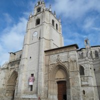
Palencia is a quiet provincial capital in Castilla y León, about 45 km north of Valladolid, on the Carrión river. Its main sight is the cathedral, known as "La Bella Desconocida" (the unknown beauty) because few visitors know it, with Gothic architecture and a rich interior.
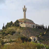
On a hill above the city, a 30-meter statue of Cristo del Otero looks over the plain. The city is compact and walkable, and a base for the Romanesque churches and the Canal de Castilla of the province.

Palência – A planear uma viagem?
Cria o teu itinerário dia a dia na app Tripomatic.


Quando visitar
Spring and autumn are the best times. Summers are hot and dry, and winters are cold with frost. The Fiestas de San Antolín, in early September, are the main festival, with bulls, concerts and fairs.
Semana Santa processions are held in spring.
Melhor altura para visitar: maio, junho, julho, agosto, setembro
Principais atrações
- Catedral de San Antolín is a 14th-16th century cathedral with a Visigothic crypt, a rich altarpiece and a museum.
- Cristo del Otero is a 30-meter statue of Christ on a hill above the city, with a small museum in the base.
- Museo Catedralicio is the cathedral museum, with tapestries and paintings.
- The Iglesia de San Miguel is a Gothic church, where El Cid is said to have married.
- The Iglesia de San Francisco and the Iglesia de San Lázaro are old churches in the center.
- The Museo Díaz Caneja is a museum of a local painter.
- The Calle Mayor is a long pedestrian street with arcades, shops and cafés.
Listas em destaque

O que experienciar
- Visit the cathedral and its crypt.
- Walk up to the Cristo del Otero for the views.
- Stroll along the Calle Mayor and have tapas.
- Cycle or walk on the Canal de Castilla.
- Visit a Romanesque church in the province.
Excursões e atividades
Palência — Mapa

Passeios de um dia
- Valladolid (about 45 km): the regional capital.
- Burgos (about 90 km): a Gothic cathedral.
- León (about 120 km): a cathedral with stained glass.
- Baños de Cerrato (about 20 km): a Visigothic church dated 661.
- Canal de Castilla: a historic canal with walking and cycling paths.
- Salamanca (about 170 km): a university city.
Onde explorar
Como chegar
- By train: High-speed AVE and Alvia trains link Palencia with Madrid in about 1 hour 30 minutes to 2 hours, and with León, Valladolid and Burgos. Book on Renfe.
- By air: Valladolid airport is about 45 km away. Madrid-Barajas is about 250 km.
- By bus: Buses connect to nearby cities.
- By car: The A-62 and A-67 motorways.
Como se deslocar
- On foot: The center is flat and compact, and all main sights are walkable.
- Cycling: Flat, with bike paths along the river.
- Taxi and bus: Local buses and taxis are available.
Conduzir
- Is a car worth it?: Not for the city, but useful for the province's churches and the canal.
- Parking: Paid parking in the center, with free options on the edge.
- Roads: Roads are good and traffic is light.
Comida e bebida
Palencia's food is hearty Castilian cooking. Try lechazo asado (roast lamb), morcilla (blood sausage), cordero, pimientos rellenos and the quesos (cheese) of the region. The Cerrato area makes rosados (rosé wines), and the typical sweet is the rosquilla and mantecados.
Segurança e saúde
Palencia is a safe city. Winter can be cold with ice, so dress warmly. The steps at the Cristo del Otero can be wet and slippery.
História
Palencia was a Celtiberian and Roman town, and in 1208 the first university of Spain was founded here, though it later moved to Salamanca. The Visigothic crypt of San Antolín dates to the 7th century.
The cathedral was built from the 14th to the 16th century, and the Canal de Castilla, built in the 18th and 19th centuries, brought trade to the area.
Factos sobre o país
Quick practical facts for Spain at a glance:
- Moeda
- Euro EUR € · Pagamentos com cartão · Amplamente aceite
- Números de emergência
- 112
- Eletricidade
- 230 V · 50 HzTipo C / Tipo F
- Idiomas
- espanhol
- Água da torneira
- Própria para beber
- Sentido de condução
- Direita
- Indicativo telefónico
- +34

Palência – Planeia os teus dias
Transforma os lugares deste guia num verdadeiro itinerário, com rotas inteligentes, estimativas de tempo e tudo o que precisas para uma viagem perfeita.


Destinos relacionados


Data: © OpenStreetMap contributors, Wikidata, Wikipedia, Tripomatic, Official websites, geoBoundaries (CC BY 4.0). Tours by GetYourGuide. We earn commission from bookings. Travel guide generated with AI.