



Beskydy Protected Landscape Area
The Beskydy Protected Landscape Area covers the rounded, forested peaks of the Moravian-Silesian Beskids. It sits in the far east of the Czech Republic, close to the Slovak and Polish borders. Mountain meadows, dense spruce forest, and wooden shepherd huts locals call "salaše" give the region a different feel from the country's historic cities. It suits hikers, families who want a few active days outdoors, and travelers curious about the Wallachian shepherd culture that shaped these hills.
There is no single city at the center of the region. Small towns such as Rožnov pod Radhoštěm and Frenštát pod Radhoštěm sit at the foot of the mountains and make good bases for day hikes. The psychoanalyst Sigmund Freud was born just north of the range, in the nearby town of Příbor.

Beskydy Protected Landscape Area – Planning a Trip?
Build your day-by-day itinerary in the Tripomatic app.


When to visit
Summers (June to September) are mild and good for hiking, with long daylight hours on the ridges. Snow can linger on the highest peaks into April. Winter (December to March) brings reliable snow for skiing around Pustevny.
Plan around the Rožnov Wallachian Folk Festival (Rožnovské slavnosti), held at the open-air museum in summer. It brings folk music, dancing, and craft demonstrations from across the region.
Best time to visit: June, August
Late summer, especially August and September, usually brings the best mix of warm days and fewer crowds.
Top sights
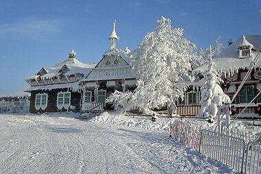




Pustevny is the region's most recognizable spot, a mountain saddle lined with wooden buildings in the Art Nouveau style of architect Dušan Jurkovič. It is the starting point for the ridge walk toward Radhošť and a busy ski area in winter.
Climb Jurkovičova rozhledna, a wooden lookout tower on a hill above Rožnov pod Radhoštěm, built to an unrealized Jurkovič design, for a panorama over the surrounding ridges.
Lysá hora is the highest peak of the Moravian-Silesian Beskids at 1,323 meters. The summit has a mountain hut and open views on a clear day, and it is one of the most popular hikes in the range.
Bezručova chata is a historic mountain hut on the slopes below Lysá hora, a good stop or overnight base for a longer hike.
Pulčín - Hradisko is a sandstone rock city with the remains of a medieval hillfort, in the southern part of the protected area near the Slovak border.
Valašské muzeum v přírodě - Valašská dědina recreates a 19th-century Wallachian village with original wooden farmhouses, a church, and a mill moved here from villages across the region. It is the best introduction to the shepherd culture that shaped these mountains.
Featured Lists


Majestic Mountain Vistas
The Beskydy Mountains feature prominent peaks like Lysá hora, the range's highest point at 1,323 meters, and Radhošť, home to the Radegast statue and a 19th-century chapel. This collection includes specialized observation structures like the Stezka Valaška treetop walkway and the converted water tower at Tetřev. Visitors can explore various massifs including Smrk and the Ropice ridge, complemented by historic mountain huts and natural rock overlooks such as Medvědí skála.
18 places


What to experience
- Ride the chairlift up to Pustevny, then walk the ridge trail toward the wooden chapel and statues on Radhošť.
- Sample fresh sheep's cheese straight from a mountain salaš in summer, when shepherds still graze their flocks on the high meadows.
- Sled or cross-country ski the marked winter trails around Pustevny.
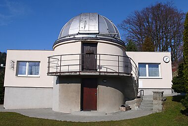
- Join an evening stargazing session at Hvězdárna Vsetín, a public observatory in the foothills.
- Watch folk dancing and craft demonstrations at the Rožnov Wallachian Folk Festival, held at the open-air museum each summer.
Tours & Activities
Beskydy Protected Landscape Area — Map

 Open the interactive map
 Day trips
The mountain villages make a good base, but a few towns at the foot of the hills are worth the short trip down.
- Frenštát pod Radhoštěm (≈15 min by car from Pustevny) is the closest gateway town, with a market square and a direct bus and cable car link up into the hills.
- Štramberk (≈30 min) is known for Štramberská trúba, a round medieval tower, and for a local gingerbread pastry shaped like an ear.
- Kopřivnice and nearby Hukvaldy (≈30-40 min) pair Muzeum osobních automobilů Tatra, tracing over a century of Tatra vehicles, with castle ruins tied to composer Leoš Janáček.
- Příbor (≈35 min) has a well-preserved historic core and Rodný dům Sigmunda Freuda, the birthplace of Sigmund Freud, now a small museum.
- Ostrava (≈45-60 min) is the region's largest city, with converted industrial sites such as the Lower Vítkovice ironworks.
Getting there
- By air: The nearest airport is Ostrava Leoš Janáček Airport (OSR), about 45–60 minutes by car from the mountains, though it has only limited scheduled service. Katowice Airport (KTW) in Poland, about 1.5–2 hours away, has more low-cost connections and is the airport many travelers use instead. Prague and Vienna are roughly 3.5 to 4 hours away by car, and a little longer by train.
- By train: Regional trains connect Ostrava, Frýdek-Místek, and Frenštát pod Radhoštěm with the rest of the country. Change at Ostrava's main station or at Valašské Meziříčí for the branch lines into the hills. Book on České dráhy.
- By bus: Regional coaches link Ostrava and Zlín with the mountain towns and reach some trailheads that trains do not.
Getting around
- Public transit: Regional buses and trains reach the main towns; in winter, extra shuttle buses run to Pustevny from Rožnov pod Radhoštěm and Frenštát pod Radhoštěm. Buy tickets from the driver or through the regional transport app.
- Taxi / ride-hailing: Uber and Bolt operate in Ostrava but rarely reach the mountain villages; a car or the local bus network works better here.
- On foot / cycling: The hiking network is extensive and well marked with the Czech system of colored trail signs. Cycling and mountain biking are popular on the marked greenways, though the terrain is hilly.
Driving
- Is a car worth it?: Yes. Many trailheads and villages are not on the rail network, and a car makes it easy to reach different parts of the mountains in one trip.
- Parking: Paid car parks sit at the main trailheads, including Pustevny; they fill up early on weekends and holidays in both summer and winter.
- Restrictions: None specific to this region — no low-emission or congestion zones apply here.
Food & drink
Wallachian mountain food centers on sheep. Look for brynza, a soft sheep's cheese, and frgál, a large sweet flatbread topped with fruit or poppy seed. Kyselica, a sour cabbage soup, and slivovice, a strong plum brandy, are also regional staples.
The best places to try them are mountain chalets called salaše along the hiking trails, where shepherds still sell fresh cheese in summer, and the small restaurants around Rožnov pod Radhoštěm's town square.
Safety & health
The region is very safe, with low crime and few scams aimed at tourists.
Mountain weather changes quickly, even in summer. Wear proper hiking shoes, carry a layer for wind and rain, and stick to the marked trails. For a mountain emergency, call the Mountain Rescue Service (Horská služba) at 1210, in addition to the general emergency number 112.
History
Beskydy has been shaped by the Wallachian colonization of the 16th and 17th centuries, when shepherds migrated along the Carpathian mountains from the Balkans and settled these highlands. They brought transhumance sheep farming, a distinct dialect, and the wooden building style still visible in mountain villages and preserved at Valašské muzeum v přírodě - Valašská dědina.
During World War II, the forests sheltered anti-Nazi partisan resistance fighters, and several memorials in the hills mark their hideouts and clashes with German forces. The Beskydy Protected Landscape Area itself was established in 1973.
Country facts
Quick practical facts for the Czech Republic at a glance:
- Currency
- Czech Koruna CZK Kč · Card payments · Commonly accepted
- Emergency numbers
- 112
- Electricity
- 230 V · 50 HzType C / Type E
- Languages
- Czech
- Tap water
- Safe to drink
- Driving side
- Right
- Calling code
- +420


Beskydy Protected Landscape Area – Plan Your Days
Turn the places from this guide into a real itinerary, with smart routing, time estimates, and everything you need for a perfect trip.




